Pattern to remain active into next week with the threat of more storms and potential severe weather plus a pattern change to cooler conditions by mid-month
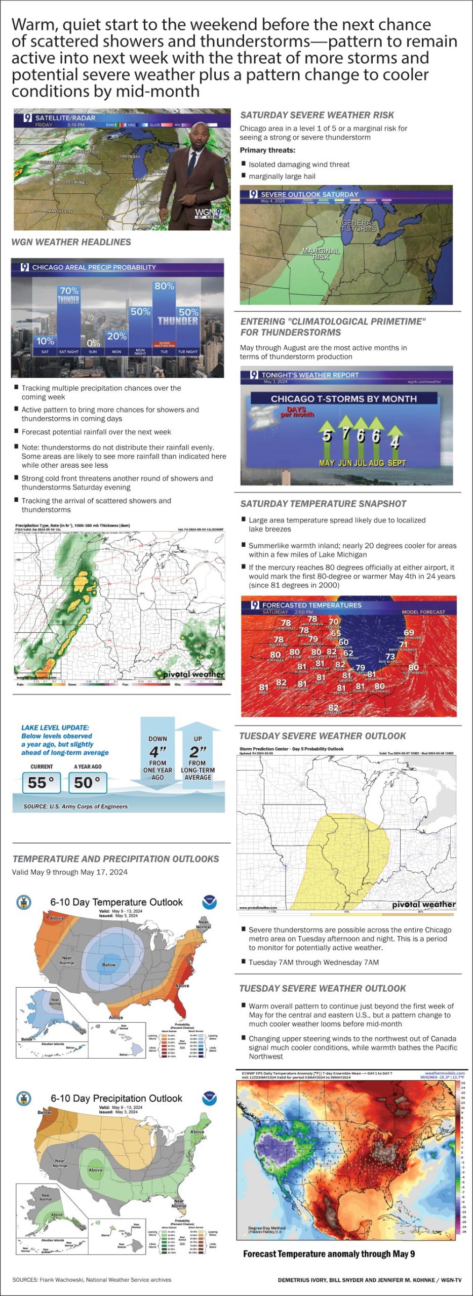
WGN WEATHER HEADLINES

- Tracking multiple precipitation chances over the coming week
- Active pattern to bring more chances for showers and thunderstorms in coming days
- Forecast potential rainfall over the next week
- Note: thunderstorms do not distribute their rainfall evenly. Some areas are likely to see more rainfall than indicated here while other areas see less
- Strong cold front threatens another round of showers and thunderstorms Saturday evening
- Tracking the arrival of scattered showers and thunderstorms

TUESDAY SEVERE WEATHER OUTLOOK

- Severe thunderstorms are possible across the entire Chicago metro area on Tuesday afternoon and night. This is a period to monitor for potentially active weather.
- Tuesday 7AM through Wednesday 7AM

TEMPERATURE AND PRECIPITATION OUTLOOKS
Valid May 9 through May 17, 2024


SATURDAY SEVERE WEATHER RISK
Chicago area in a level 1 of 5 or a marginal risk for seeing a strong or severe thunderstorm
Primary threats:
- Isolated damaging wind threat
- marginally large hail

ENTERING “CLIMATOLOGICAL PRIMETIME” FOR THUNDERSTORMS
May through August are the most active months in terms of thunderstorm production

SATURDAY TEMPERATURE SNAPSHOT
- Large area temperature spread likely due to localized lake breezes
- Summerlike warmth inland; nearly 20 degrees cooler for areas within a few miles of Lake Michigan
- If the mercury reaches 80 degrees officially at either airport, it would mark the first 80-degree or warmer May 4th in 24 years (since 81 degrees in 2000)

FORECAST TEMPERATURE ANOMALY
- Warm overall pattern to continue just beyond the first week of May for the central and eastern U.S., but a pattern change to much cooler weather looms before mid-month
- Changing upper steering winds to the northwest out of Canada signal much cooler conditions, while warmth bathes the Pacific Northwest

