
Less than 10 days after Hurricane Helene made landfall in Florida, the state is now bracing for another potential storm brewing in the Gulf of Mexico.
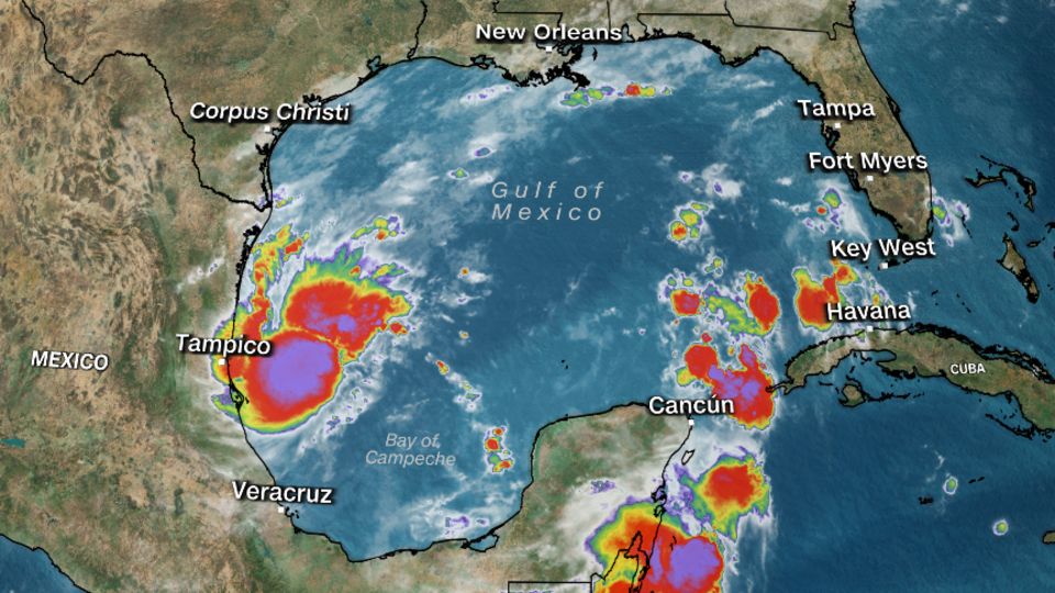
Tropical Depression 14 formed in the western Gulf on Saturday morning and is expected to become Tropical Storm Milton in the next 24 hours, the National Hurricane Center said. The 13th named storm, which uses the letter M, is running ahead of pace – it doesn’t usually occur until October 25.
“The depression is forecast to quickly intensify while it moves eastward to northeastward across the Gulf of Mexico and be at or near major hurricane strength when it reaches the west coast of the Florida Peninsula mid week,” the hurricane center said.
There is very good agreement with weather forecast models this system will continue its trek east, making landfall on the west coast of the Florida Peninsula Wednesday.
Hurricane watches, as well as storm surge watches, will likely be issued for portions of the Florida coast on Sunday.

“Regardless of development, locally heavy rains could occur over portions of Mexico during the next day or two, and over much of Florida late this weekend through the middle of next week,” the NHC said.
The storm threat comes after Helene made landfall September 26 on Florida’s Big Bend as a Category 4 and created a 500-mile path of destruction with catastrophic flooding, damaging winds and power outages. Local authorities have reported more than 200 deaths across six states and fear that number could rise.
Helene was one of the largest storms the Gulf of Mexico has seen in the last century.
The latest storm forecast at this point calls for widespread totals of 4 to 6 inches of rain across almost the full length of the state, from Gainesville down through Key West, with isolated higher amounts up to 10 inches possible through Thursday. Tampa has already already seen more than 20 inches of rainfall above normal for the year. Cities like Melbourne, Jacksonville, Naples and Fort Myers all have more than a foot of surplus rainfall so far this year as well.
There is also an increasing risk of storm surge for the western Florida Peninsula as early as late Tuesday or Wednesday. Damaging winds, tornadoes and waterspouts will also be possible next week.
The hurricane center is warning people in Mexico’s Yucatan Peninsula, the Florida Peninsula, the Florida Keys, as well as the Bahamas to closely monitor this system this weekend and early next week for any impacts.
For more CNN news and newsletters create an account at CNN.com
The post Florida is on alert as a new tropical depression forms in the Gulf, just days after Hurricane Helene appeared first on Patabook News .