
(This story was updated to add new information.)
Hurricane Helene is closing in on Florida with landfall expected in the Big Bend area Thursday. Helene is expected to slam into Florida as a massive Category 4 hurricane with winds up to 132-mph, according to the National Hurricane Center.
➤ Weather alerts via text: Sign up to get updates about current storms and weather events by location
➤ Live updates for Collier County: Get the latest for the Naples area here.
➤ Live updates for Lee County: Get the latest for the Fort Myers area here.
➤ Live updates for Sarasota-Manatee Counties: Get the latest for Sarasota-Bradenton here.
➤ Live updates for Volusia County: Get the latest for the Daytona Beach area here.
“Helene is expected to rapidly grow into a very large and powerful hurricane. The threat of storm surge along the Big Bend of Florida is life-threatening and destructive,” warned AccuWeather Lead Hurricane Expert Alex DaSilva. “Serious impacts will be felt hundreds of miles away from the center of circulation.”
➤ Emergency preparedness: What to pack in a ‘go bag’
Helene poses dangers of life-threatening storm surge, destructive winds and flash flooding along the entire west coast of Florida and the Big Bend, the NHC reported. The highest inundation levels and potentially catastrophic hurricane-force winds are expected along the Big Bend coast.
Preparations to protect life and property along the Florida Big Bend coast “should be rushed to completion,” the NHC said.
When will Helene hit Florida?
Landfall is expected along the coast of the Florida Big Bend Thursday night, according to the National Hurricane Center.
The latest information suggests landfall may be near Apalachicola, Florida, between 9 and 11 p.m. Thursday, according to AccuWeather.
— Cheryl McCloud
Sarasota area forecast for tropical storm-force winds
Sarasota and Manatee counties can expect winds of 39-57 mph starting early this morning and extending into the afternoon.
The current National Weather Service forecast calls for 3-6 inches of rain, with up to 10 inches in select areas; a storm surge of 4-7 feet in coastal Sarasota and 5-8 feet in coastal Manatee; and heavy winds, especially along the coast.
— Brian Ries
Volusia County braces for rain, wind. SunRail service suspended
Volusia County is expected to experience tropical storm-force winds beginning around noon, with sporadic gusts up to 60 mph, according to the National Weather Service. Rainfall will range from 1 to 4 inches with possible flooding in low-lying and urban areas. There is a possibility of overnight tornados that will increase Thursday.
All Volusia County offices will be closed on Thursday, including library branches. Beach driving, beach restrooms, and coastal parks will be closed tomorrow, with the inlet parks closing at 11 a.m.
The Florida Department of Transportation has announced that SunRail will not operate on Thursday with service expected to resume on Friday pending inspections. Votran was planning to run Thursday morning, but service may be suspended at any point during the day. The landfill and trash collection in unincorporated areas will operate on a regular schedule.
Tornado warning for Collier County. Take cover!
Take cover, a tornado warning was issued by the National Weather Service in Miami at 5:04 a.m. on Thursday, Sept. 26. That includes the following counties: Collier.
The warning was set to expire at 6 a.m. Thursday.
The NWS recommends: “TAKE COVER NOW! Move to an interior room on the lowest floor of a sturdy building. Avoid windows. If you are outdoors, in a mobile home, or in a vehicle, move to the closest substantial shelter and protect yourself from flying debris. Tornadoes are extremely difficult to see and confirm at night. Do not wait to see or hear the tornado. TAKE COVER NOW!”
What should you do today if you live in Florida?
➤ How to prepare for a hurricane
Your hurricane preparations should be complete. If advised to evacuate, please do so before conditions become too dangerous. Keep an eye on weather updates. Make sure you monitor the latest conditions.
— Cheryl McCloud
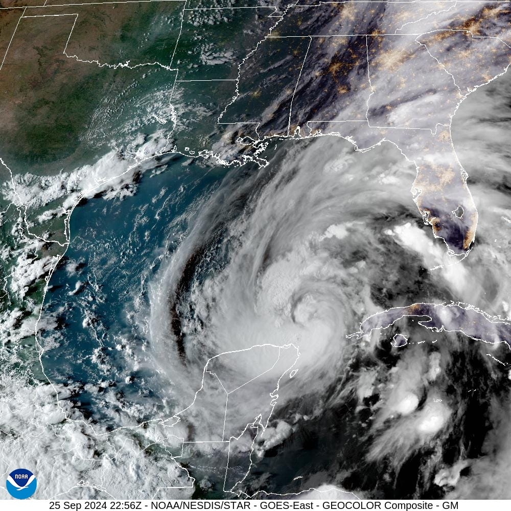
Hurricane Helene current path
Helene is moving toward the north-northeast near 12 mph. This general motion is expected to continue with a significant increase in forward speed during the next 24 hours.
On the forecast track, Helene will move across the eastern Gulf of Mexico today and cross the Florida Big Bend coast this evening or early Friday morning. After landfall, Helene is expected to turn northwest and slow down over the Tennessee Valley on Friday and Saturday.
Maximum sustained winds have increased to near 90 mph, with higher gusts.
Strengthening is forecast, and Helene is expected to be a major hurricane when it reaches the Florida Big Bend coast this evening.
— Cheryl McCloud
Hurricane Helene current location
As of 5 a.m. Thursday, the National Hurricane Center put Hurricane Helene in the Gulf of Mexico and tracking north-northeast:
-
Location: 350 miles southwest of Tampa; 385 miles south of Apalachicola
-
Maximum sustained winds: 90 mph
-
Movement: north-northeast at 12 mph
-
Pressure: 966 mb
-
Next advisory: 8 a.m.
Helene could bring up to 20 feet of storm surge
The combination of a life-threatening storm surge and the tide will cause normally dry areas near the coast to be flooded by rising waters moving inland from the shoreline, according to the NHC.
The water could reach the following heights above ground somewhere in the indicated areas if the peak surge occurs at the time of high tide:
-
Carrabelle, FL to Suwannee River, FL…15-20 ft
-
Apalachicola, FL to Carrabelle, FL…10-15 ft
-
Suwannee River, FL to Chassahowitzka, FL…10-15 ft
-
Chassahowitzka, FL to Anclote River, FL…8-12 ft
-
Indian Pass, FL to Apalachicola, FL…6-10 ft
-
Anclote River, FL to Middle of Longboat Key, FL…5-8 ft
-
Tampa Bay…5-8 ft
-
Middle of Longboat Key, FL to Englewood, FL…4-7 ft
-
East of Mexico Beach, FL to Indian Pass, FL…3-5 ft
-
Englewood, FL to Flamingo, FL…3-5 ft
-
Charlotte Harbor…3-5 ft

Warnings, watches issued for Florida
Storm surge warning: A Storm Surge Warning means there is a danger of life-threatening inundation, from rising water moving inland from the coastline, during the next 36 hours in the indicated locations.
Hurricane warning: A Hurricane Warning means that hurricane conditions are expected somewhere within the warning area. A warning is typically issued 36 hours before the anticipated first occurrence of tropical-storm-force winds, conditions that make outside preparations difficult or dangerous.
Hurricane watch: A hurricane watch means that hurricane conditions are possible within the watch area. A watch is typically issued 48 hours before the anticipated first occurrence of tropical-storm-force winds.
Tropical storm warning: A Tropical Storm Warning means that tropical storm conditions are expected somewhere within the warning area within the next 36 hours.
-
Florida Keys, including the Dry Tortugas
-
Flamingo to Anclote River, including Tampa Bay
-
West of Mexico Beach to the Okaloosa/Walton County Line
-
Flamingo northward to Little River Inlet
-
Lake Okeechobee
Evacuations ordered for Florida counties ahead of Helene
According to the Florida Division of Emergency Management, evacuations have been ordered for the following Florida counties:
MANDATORY
Charlotte County: Evacuations have been ordered for barrier islands, low-lying and flood prone areas, manufactured homes, and homes that don’t meet 1995 building codes.
Citrus County: Mandatory Evacuation: For licensed Skilled Nursing Facilities and Assisted Living Facilities located in ZONE A ONLY: Wednesday, September 25, 8AM Those living within Evacuation Zone A or any structure countywide not capable of withstanding tropical storm force winds or greater: Wednesday, September 25, 2PM
Dixie County: Dixie County Emergency Management has issued a mandatory evacuation order in preparation for Hurricane Helene. Evacuations will begin at 10AM on Wednesday September 25, 2024 for the following: • All coastal communities including: Suwanee, Horseshoe Beach, Jena, and the immediate surrounding areas. • Mobile Homes and Manufactured homes throughout the county. • Recreational Vehicles County Wide. • Low Lying Areas in the county.
Franklin County: In response to the projected trajectory and intensity of Tropical Storm Helene, Franklin County will implement a mandatory evacuation for the entire county, effective at 12:00 PM on Wednesday, September 25, 2024.
Gulf County: 09/24/24 1000 hours – All non-residents and all Recreational Vehicles (RV’s) in Indian Pass, Cape San Blas, & Simmons Bayou MUST be evacuated by 8:00 AM Wednesday (09/25)
Hillsborough County: Mandatory Evacuation for Zone A and All Mobile and Manufactured Homes Ahead of Tropical Storm Helene.
Jefferson County: Residents of mobile homes, low lying flood prone areas, RV’s, modular homes, and homes that are not up to current hurricane standards.
Lafayette County: Lafayette County Board of County Commissioners and Division of Emergency Management has issued a mandatory evacuation order for all residents living in mobile homes, travel trailers, structurally compromised housing and low lying areas for the entire county. The mandatory evacuations will go into effect on Thursday, September 26, 2024, at 8:00 AM.
Leon County: Leon County has issued a mandatory evacuation for residents of mobile and manufactured homes due to the threat of hurricane-force winds. Manufactured and mobile home residents in Leon County should seek safer shelter by 8 a.m. on Thursday, September 26.
Levy County: A Mandatory Evacuation Order is issued for: -Recreational vehicle parks throughout the county, and they shall be removed from the county to the maximum extent possible. -Mobile Homes and Manufactured homes throughout the county. Coastal Communities in the county. Low-Lying areas throughout the county.
Madison County: Due to expected Hurricane force winds, Madison County has a VOLUNTARY evacuation in place for mobile homes, sub-standard housing and flood prone areas.
Manatee County: Manatee County announced a call for evacuation for residents who live in Level A flood zones starting Wednesday morning at 10 a.m. in preparation for Tropical Storm Helene. Evacuation Level A includes all of Anna Maria Island and Manatee portions of Longboat Key, as well as coastal mainland areas. The evacuation also applies to all low-lying and flood-prone areas as well as all mobile and manufactured homes.
Pasco County: Mandatory evacuations will go into effect Wednesday, September 25, at 9:00 a.m. for the following: Evacuation Zone A. Everyone living in a manufactured home, mobile home or RV anywhere in Pasco Everyone in low-lying areas or areas prone to flooding Everyone in an area ordered evacuated by local authorities due to life-safety hazards Voluntary evacuations will go into effect Wednesday, September 25, at 9:00 a.m. for the following: Evacuation Zones B and C Everyone registered with Pasco as a Special Needs Resident Everyone who would be vulnerable in the event of a power loss.
Pinellas County: Mandatory Evacuation Order only for our long-term healthcare residential facilities, which includes hospitals, nursing homes and assisted living facilities that or in Zone A. https://www.facebook.com/PinellasGov
Sarasota County: Sarasota County has declared a local state of emergency and has called for evacuations of Level A manufactured home communities starting Wednesday, Sept. 25, at 7 a.m. Evacuation centers in Sarasota County will open at noon Wednesday.
Taylor County: The Taylor County Sheriff’s Office is issuing a Mandatory Evacuation Order for everyone in Taylor County due to the intensity of the forecasted Hurricane Helene effective immediately.
Wakulla County: All evacuation zones in Wakulla County are under a mandatory evacuation order. On September 24, 2024, the Wakulla County Board of County Commissioners issued a countywide mandatory evacuation for citizens and visitors by no later than 8 a.m. on Thursday, September 26, 2024.
VOLUNTARY
-
Alachua County
-
Baker County
-
Gadsden County
-
Hamilton County
-
Jefferson County
-
Madison County
-
Suwannee County
-
Union County
Hurricane Helene projected path

Weather radar Florida

Tropical Storm Helene tracker
Helene spaghetti models
Stay informed. Get weather alerts via text
Support local journalism by subscribing to a Florida news organization.
This article originally appeared on Tallahassee Democrat: Hurricane Helene Florida landfall today. Impact, path: Live updates
The post Helene could make Florida landfall as Category 4 storm Thursday appeared first on Patabook News .