A new study looking at landfill emissions revealed the industrial waste dumps are likely punching above their weight when it comes to methane leaks.
The report, which revealed a significant difference between observed and reported methane emissions, is especially topical in Illinois. The state recently ranked eighth in the country for highest methane emissions from landfills – up one spot from the previous year.
Landfills lead other Illinois industries like mining, metal manufacturing and food processing when it comes to the emissions. And nationally, landfills are the third-largest source of human-related methane emissions after livestock and natural gas. That’s because landfills aren’t just piles of garbage: When organic matter like food and yard waste decompose in the oxygen-free environment of a landfill, it creates methane and carbon dioxide.
Excess methane is typically burned in a flare, a process that converts most of the methane to carbon dioxide, reducing global warming impacts. While carbon dioxide is also a greenhouse gas, methane holds more than 25 times more warming power, making CO2 the lesser of two evils.
The new study produced by climate nonprofit Carbon Mapper, the U.S. Environmental Protection Agency and other agencies revealed that landfills’ methane emission rates observed through aerial technology were clocking in 1.4 times as much as than the standard data logged through the EPA’s Greenhouse Gas Reporting Program.
“Landfills are very complex, and they can be hard to measure,” said Dan Cusworth, Carbon Mapper’s director of science and the lead author of the study. “The current state of landfill monitoring from a regulatory perspective in the U.S. involves these walking surveys with basically handheld gas analyzers and someone walking paths around the landfill’s hot spots.”
The collected data is then put into a formula, and the resulting estimates are reported to the EPA. These model-based estimates have been the subject of concern in the past, with federal EPA staff members stating the formulas are flawed and emissions could be double what’s currently reported.
To circumvent the challenges of measuring methane leaks from the ground, Cusworth’s team deployed advanced remote sensing technology called imaging spectroscopy, flying drones over hundreds of landfills and collecting snapshots of methane plumes.
“By and large, we were seeing larger than predicted estimates in aggregate across all the landfills,” Cusworth said. “Not every landfill, but if you compare the landfills we surveyed against what’s reported, it suggested 40% higher emissions than what the model suggests.”
The findings also gave an important clue as to how to cut down on the unwieldy methane leaks: The emissions form the majority of landfills surveyed could be traced back to discrete, localized point sources. Meaning if the advanced monitoring were used more widely and hand-in-hand with isolating the sources, “that’s be a pretty huge amount of methane reduction,” Cusworth said.
“We found that really this is about routine monitoring that we have to do systematically to understand where the localized hotspots are at landfills,” he added. “We think it really points to satellite observations, and we’re planning satellite launches at Carbon Mapper that uses the same technology, but that can have global reach and have more sustained monitoring across multiple locations.”
The remote sensing technology used for the study was built out of NASA, where Cusworth used to work. He likened the airborne imaging spectrometers to “a very, very advanced infrared camera.”
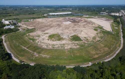
The blue-green blobs that the flying instruments capture represent methane concentrations that are elevated compared to their surroundings, identifying hot spots that could be potential origin sources for methane leaks.
Though Illinois landfills didn’t make it into the study, which includes data collected through 2022, Carbon Mapper has continued to fly.
In 2023, the organization captured images of methane plumes over several landfills in the state, including Waste Management’s Countryside Landfill in Grayslake and GFL Environmental’s Zion Landfill.
With the EPA nearing its statutory deadline to review its landfill standards this August, Carbon Mapper’s study is especially topical, said Katherine Blauvelt of climate and industry advocacy group Industrious Labs.
“Landfills are just this invisible, outsized contributor to the such potent methane emissions that are really responsible for global warming in the here and now,” she said. “This new evidence shows us that we really have a problem that needs urgent attention.”
Blauvelt said solutions like more effective landfill covers, comprehensive gas capture and timely pipe installation are at the fingertips of the EPA.
“The EPA needs to pick up the pen and update regulations to use more up-to-date technologies and practices that really get a handle on the emissions we’re seeing from landfills,“ she said. “That’s good news in the sense that we don’t need a moonshot program. This is simply updating the rules of the road to really be effective.”
For Carbon Mapper, Cusworth said the challenge will be scaling up the technology across different jurisdictions, states and landfill operators.
“There has to be this real communication between the measurement and the operation so they’re both feeding into each other and being used. We need to scale both of these and fortify that connection between the two,” he said. “This is is going to be more and more possible, not just from airborne and satellite platforms, but other things that many creative people are doing on the ground. That’s what is, in my opinion, required to really get a handle on our methane emissions across the sector.”
• Jenny Whidden, jwhidden@dailyherald.com, is a climate change and environment writer working with the Daily Herald through a partnership with Report For America supported by The Nature Conservancy. To help support her work with a tax-deductible donation, see dailyherald.com/rfa.
A methane plume hovers above Waste Management’s Countryside Landfill in Grayslake. Generated by climate nonprofit Carbon Mapper, this image is the result of remote sensing technology called imaging spectroscopy — or what lead researcher Dan Cusworth compared to an extremely advanced infrared camera. The blue-green blob represents methane concentrations that are elevated compared to the immediate surroundings, identifying hot spots that could be potential origin sources for methane leaks.
Courtesy of Carbon Mapper