MIAMI – As Ian near Florida, several hurricane watches have been issued for the state’s Gulf Coast, which could bear the brunt of the storm.
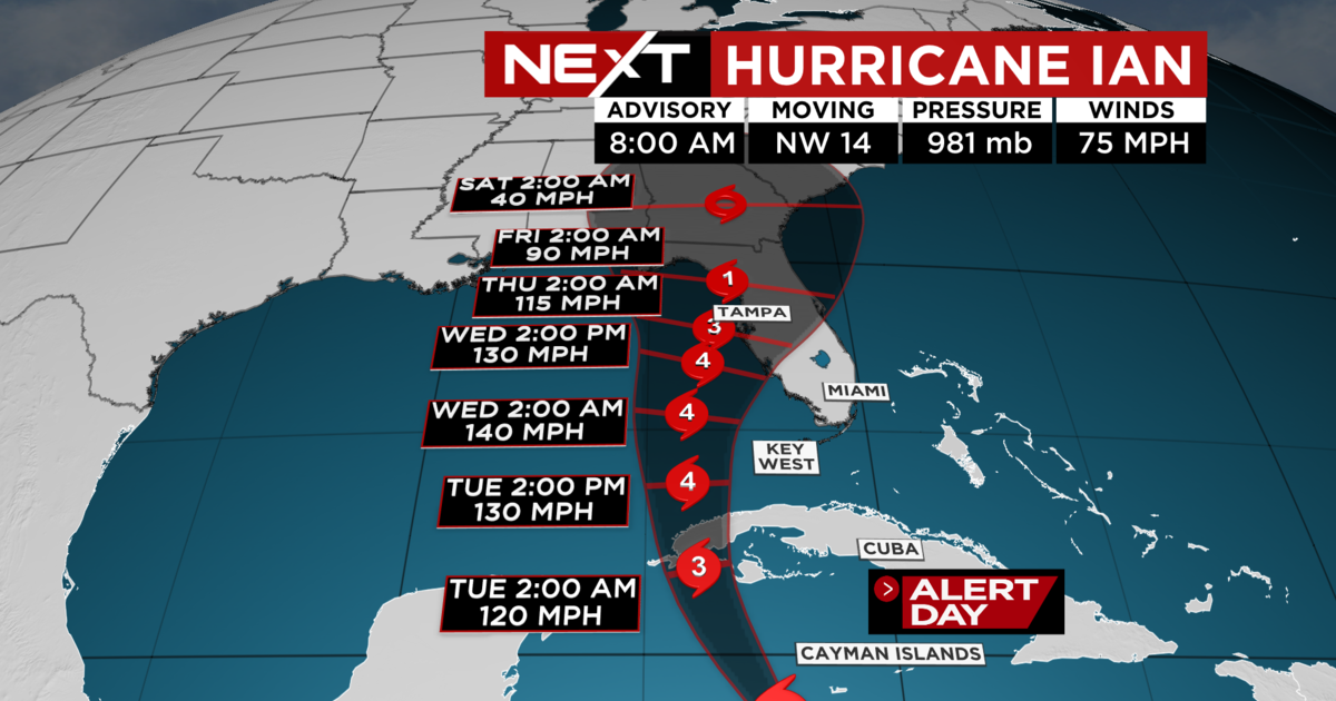
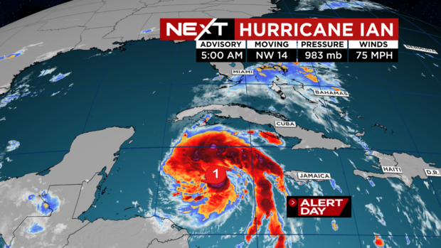
The National Hurricane Center’s 11 a.m. advisory has the Category 1 hurricane moving to the northwest at 13 miles per hour with maximum sustained winds of 80 mph.
South Florida is expected to escape the worst of the storm, which could still bring rain bands to Broward and Miami-Dade Counties.
NEXT Weather
During a Monday morning news conference, Gov. Ron DeSantis said 5,000 Florida National Guard members have been activated along with 2,000 of their counterparts from Tennessee, Georgia and North Carolina to help Florida recover.
“We know we’re going to have major impacts in the state of Florida,” he said, adding that many people in the storm’s path would likely lose power and residents should be prepared..
DeSantis issued an expanded emergency declaration over the weekend to help free up emergency protective funding along with activating members of the Florida National Guard.
His order stresses that there is a risk for a storm surge, flooding, dangerous winds, and other weather conditions throughout the state.
President Joe Biden also declared an emergency for the state, authorizing the Department of Homeland Security and the Federal Emergency Management Agency, or FEMA, to coordinate disaster relief efforts and provide assistance to protect lives and property. The president postponed a scheduled Sept. 27 trip to Florida due to the storm.
A Hurricane Warning is in effect for Grand Cayman and the Cuban provinces of Isla de Juventud, Pinar del Rio, and Artemisa.
NEXT Weather
A Hurricane Warning means that hurricane conditions are expected somewhere within the warning area, in this case within 24 to 36 hours.
A Hurricane Watch is in effect for Englewood, Florida to the Anclote River, including Tampa Bay.
A Hurricane Watch means that hurricane conditions are possible within the watch area. A watch is typically issued 48 hours before the anticipated first occurrence of tropical storm-force winds.
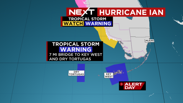
Tropical storm warnings are posted for the Cuban provinces of La Habana, Mayabeque, and Matanzas; the lower Florida Keys from Seven Mile Bridge westward to Key West; and the Dry Tortugas.
A Tropical Storm Watch is in effect for Little Cayman, Cayman Brac, and Englewood southward to Chokoloskee.

NEXT Weather
A Storm Surge Watch is in effect for the Florida Keys from the Card Sound Bridge westward to Key West, the Dry Tortugas, Florida Bay, Anclote River southward to the Card Sound Bridge, and Tampa Bay.
Ian is forecast to take a turn to the north-northwest on Monday followed by a northward motion on Tuesday with a slightly slower forward speed. A turn toward the north-northeast is forecast on Tuesday night or early Wednesday.

NEXT Weather
On the forecast track, the center of Ian is expected to pass near or west of the Cayman Islands today, and near or over western Cuba tonight and early Tuesday. Ian will then emerge over the southeastern Gulf of Mexico on Tuesday, and pass west of the Florida Keys late Tuesday, and approach the west coast of Florida on Wednesday.
The Florida Keys could see 4 to 6 inches of rain, Central West Florida could get 8 to 10 inches, with local maxima up to 15 inches, and the remainder of the Florida Peninsula could get 3 to 8 inches.
Heavy rainfall is expected to affect North Florida, eastern portions of the Florida Panhandle, and portions of the Southeast, and Mid Atlantic regions Friday and Saturday.