Remnants of what was once Hurricane Helene, which made landfall as a Category 4 storm in northwestern Florida Thursday, will bring powerful wind to southwestern Illinois Friday, with gusts as high as 55 miles per hour at times.
According to the National Weather Service, a wind advisory was in effect for Kankakee County in Illinois and Jasper and Newton Counties in Indiana from 1 p.m. Friday through midnight. According to the NWS, wind gusts between 45 and 55 mph could result in hazardous travel, tree damage and power outages.
The strongest wind gusts were expected to come Friday evening, the NWS said, starting around 4 p.m., with parts to the south seeing the strongest winds. In the Chicago area, winds could be between 35 and 45 miles per hour, the NWS said.
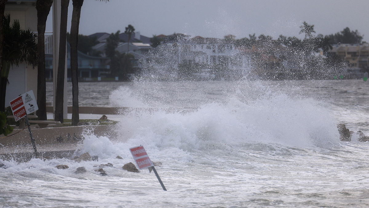
Those winds will cause large waves to build, the NWS said, leading to “dangerous lakeshore conditions,” with waves between seven and 10 feet expected to linger through the weekend.
“Avoid lakeshore trails, piers, and docks,” the NWS said. “Stay away to avoid getting swept away into potentially life-threatening conditions.”
As Helene, now a tropical storm, moves across Georgia, the outer bands of the storm were expected to move as far north as southern Illinois and southwest Indiana by Friday afternoon.
The lingering storm could bring a “renegade” shower Friday afternoon, though most parts were expected to remain cloudy and dry, NBC 5 Meteorologist Alicia Roman said.
Saturday however, more chances for rain moves in as Helene continues to move, Roman said, with scattered showers across Northeast Illinois expected late morning and early afternoon.
“There may be brief periods of heavy rain at times,” Roman said, noting a slight chance of showers Sunday was also possible.
According to Roman, temperatures Friday, Saturday and Sunday were expected to be in the low 70s.
Helene makes landfall as Category 4 in Florida with major damage
Hurricane Helene weakened to a tropical storm over Georgia with maximum sustained winds of 70 mph (110 kph) early Friday, the National Hurricane Center said.
Helene continues to weaken while moving farther inland over Georgia. The storm was about 40 miles (65 kilometers) east of Macon and about 100 miles (165 kilometers) southeast of Atlanta, moving north at 30 mph (48 kph) at 5 a.m., the center in Miami reported.
The storm made landfall in northwestern Florida as a Category 4 storm as forecasters warned the enormous system could create a “nightmare” storm surge and bring dangerous winds and rain across much of the southeastern U.S. There were at least three storm-related deaths.
The hurricane center said Helene roared ashore around 11:10 p.m. Thursday near the mouth of the Aucilla River in the Big Bend area of Florida’s Gulf Coast. It had maximum sustained winds estimated at 140 mph (225 kph). That location was only about 20 miles (32 kilometers) northwest of where Hurricane Idalia came ashore last year at nearly the same ferocity and caused widespread damage.
The hurricane’s eye passed near Valdosta, Georgia, as the storm churned rapidly north into Georgia Thursday night. The National Hurricane Center issued an extreme wind warning for the area, meaning possible hurricane-force winds exceeding 115 mph (185 kph).
At a hotel in the city of 55,000 near the Florida line, dozens of people huddled in the darkened lobby after midnight Friday as winds whistled and howled outside. Electricity was out, with hall emergency lights, flashlights and cellphones providing the only illumination. Water dripped from light fixtures in the lobby dining area and roof debris fell to the ground outside.
Helene is the third storm to strike the city in just over a year. Tropical Storm Debby blacked out power to thousands in August, while Hurricane Idalia damaged an estimated 1,000 homes in Valdosta and surrounding Lowndes County a year ago.
1.2 million in Florida without power from Helene
Helene prompted hurricane and flash flood warnings extending far beyond the coast up into northern Georgia and western North Carolina. More than 1.2 million homes and businesses were without power in Florida, more than 190,000 in Georgia and more than 30,000 in the Carolinas, according to the tracking site poweroutage.us. The governors of those states and Alabama and Virginia all declared emergencies.
One person was killed in Florida when a sign fell on their car and two people were reported killed in a possible tornado in south Georgia as the storm approached.
“When Floridians wake up tomorrow morning, we’re going to be waking up to a state where very likely there’s been additional loss of life and certainly there’s going to be loss of property,” Florida Gov. Ron DeSantis said at a news conference Thursday night.
Helene was moving rapidly inland after making landfall, with the center of the storm set to race from southern to northern Georgia through early Friday morning. The risk of tornadoes also would continue overnight and into the morning across north and central Florida, Georgia, South Carolina and southern North Carolina, forecasters said. Later Friday, there would be the risk of tornadoes in Virginia.
“Helene continues to produce catastrophic winds that are now pushing into southern Georgia,” the hurricane center said in an update at 1 a.m. Friday. “Persons should not leave their shelters and remain in place through the passage of these life-threatening conditions.”
Even before landfall, the storm’s wrath was felt widely, with sustained tropical storm-force winds and hurricane-force gusts along Florida’s west coast. Water lapped over a road in Siesta Key near Sarasota and covered some intersections in St. Pete Beach. Lumber and other debris from a fire in Cedar Key a week ago crashed ashore in the rising water.
Beyond Florida, up to 10 inches (25 centimeters) of rain had fallen in the North Carolina mountains, with up to 14 inches (36 centimeters) more possible before the deluge ends, setting the stage for flooding that forecasters warned could be worse than anything seen in the past century.
Heavy rains began falling and winds were picking up earlier Thursday in Valdosta, Georgia, near the Florida state line. The weather service said more than a dozen Georgia counties could see hurricane-force winds exceeding 110 mph (177 kph).
Sheriff’s office issues grave warning to those who don’t evacuate
In south Georgia, two people were killed when a possible tornado struck a mobile home on Thursday night, Wheeler County Sheriff Randy Rigdon told WMAZ-TV. Wheeler County is about 70 miles (113 kilometers) southeast of Macon.
The storm made landfall in the sparsely-populated Big Bend area, home to fishing villages and vacation hideaways where Florida’s Panhandle and peninsula meet.
“Please write your name, birthday, and important information on your arm or leg in a PERMANENT MARKER so that you can be identified and family notified,” the sheriff’s office in mostly rural Taylor County warned those who chose not to evacuate in a Facebook post, the dire advice similar to what other officials have dolled out during past hurricanes.
Still, Philip Tooke, a commercial fisherman who took over the business his father founded near the region’s Apalachee Bay, planned to ride out this storm like he did during Hurricane Michael and the others: on his boat. “If I lose that, I don’t have anything,” Tooke said.
Michael, a Category 5 storm, all but destroyed one town, fractured thousands of homes and businesses and caused some $25 billion in damage when it struck the Florida Panhandle in 2018.