TAMPA, Fla. (WFLA) – Helene made landfall in Florida’s Big Bend region on Thursday night, according to the National Hurricane Center. Forecasters warn that the enormous system could create a “nightmare” storm surge and bring dangerous winds and rain across much of the southeastern U.S.
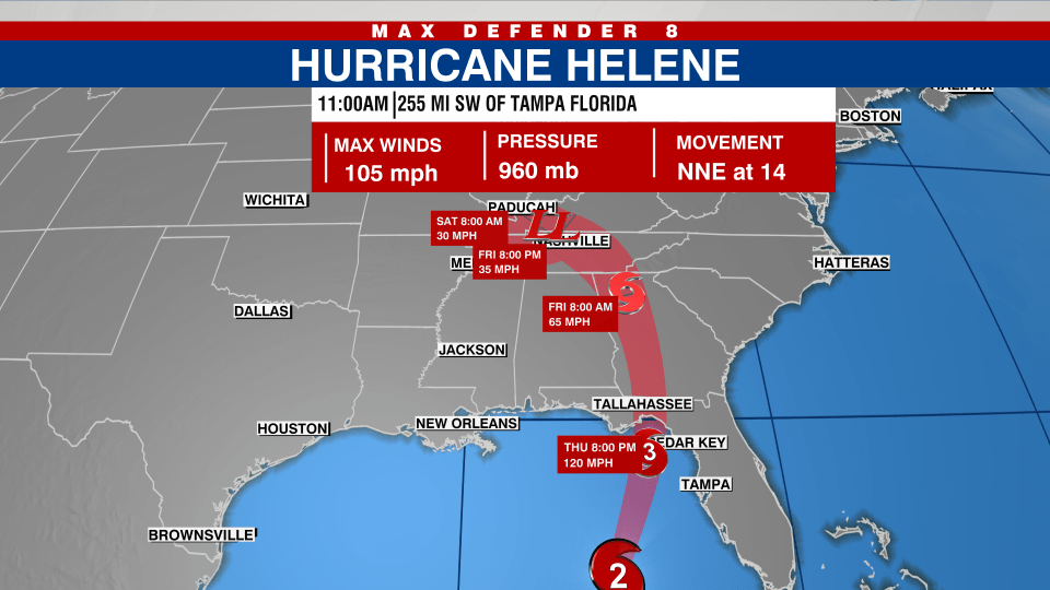
At 11 p.m., the NHC reported that Helene had maximum sustained winds of 140 and was located 65 miles west of Cedar Key while moving north-northeast at 24 mph. It made landfall at the mouth of the Aucilla River at 11:20 p.m.
The storm is expected to bring “unsurvivable” storm surge of up to 20 feet to the Big Bend area, according to the National Weather Service in Tallahassee, which called it a “nightmare surge scenario.”
Jeff Berardelli, the chief meteorologist at Nexstar’s WFLA, said residents in the Nature Coast and Big Bend should be heeding all safety and evacuation advice from officials.
“You cannot survive 20 feet or even 15 feet of storm surge,” Berardelli said. “If you’re near the water and you know you’re going to flood, especially if you’re in a mobile home, too, you’ve got to go. You cannot take your chances. This is not survivable.”
Hurricane Helene is expected to weaken after making landfall, but its “fast forward speed will allow strong, damaging winds, especially in gusts, to penetrate well inland across the southeastern United States,” including in the southern Appalachian Mountains, the hurricane center said.
“Just hope and pray that everybody’s safe,” said Connie Dillard, of Tallahassee, as she shopped at a grocery store with thinning shelves of water and bread before hitting the highway out of town. “That’s all you can do.”
NHC models show Helene likely continuing a north-northeast track through landfall before turning northwestward and slowing down over the Tennessee Valley on Friday and Saturday.
“Regardless of how strong it is, it is a very large storm,” Jack Beven, a senior hurricane specialist at the National Hurricane Center in Miami, said. “It’s going to have impacts that cover a large area.”
Hurricane warnings and flash flood warnings extended far beyond the coast up into south-central Georgia. The governors of Florida, Georgia, and the Carolinas have all declared emergencies in their states.
One person was killed in Florida when a sign fell on their car and two people were reported killed in a possible tornado in south Georgia as the storm approached, the Associated Press reports.
Georgia state meteorologist Will Lanxton said tropical storm-force winds are expected throughout Georgia. Lanxton said metro Atlanta hasn’t seen sustained tropical storm winds since Hurricane Irma in 2017.
“I think we’re going to see some significant power outages, probably nothing like we’ve seen, because it’s 159 counties wide,” said James Stallings, director of the Georgia Emergency Management and Homeland Security Agency.
Helene is projected to drop 6 to 12 inches of rain over portions of the southeastern U.S. into the southern Appalachians, with isolated totals reaching roughly 20 inches.
There is also a risk of tornadoes forming Thursday night in Florida, southeast Georgia, central and southern South Carolina nd southern North Carolina. The tornado risk will continue Friday across the Carolinas and up to southern Virginia.
Officials anticipate widespread power outages caused by the storm. As of 4 p.m. CDT, more than 90,000 customers in Tampa, Florida were already without electricity.
Along Florida’s Gulf Coast, school districts and multiple universities have canceled classes. Georgia emergency officials recommended all schools, public and private, close on Friday.
Spaghetti Models for Hurricane Helene

Helene is forecast to be one of the largest storms in breadth in years to hit the region, said Colorado State University hurricane researcher Phil Klotzbach. He said since 1988, only three Gulf hurricanes were bigger than Helene’s predicted size: 2017’s Irma, 2005’s Wilma and 1995’s Opal.
Meanwhile, Tropical Storm Isaac formed Wednesday in the Atlantic Ocean and was expected to strengthen as it moves eastward, possibly becoming a hurricane by the end of the week, forecasters said. Isaac was about 690 miles northeast of Bermuda with top sustained winds of 50 mph, according to the National Hurricane Center in Miami. It was moving east at about 12 mph.
The National Oceanic and Atmospheric Administration has predicted an above-average Atlantic hurricane season this year because of record-warm ocean temperatures.
Helene arrived barely a year since Hurricane Idalia slammed into Florida’s Big Bend and caused widespread damage. Idalia became a Category 4 in the Gulf of Mexico but made landfall as a Category 3 near Keaton Beach, with maximum sustained winds near 125 mph (205 kph).
The Associated Press contributed to this report.