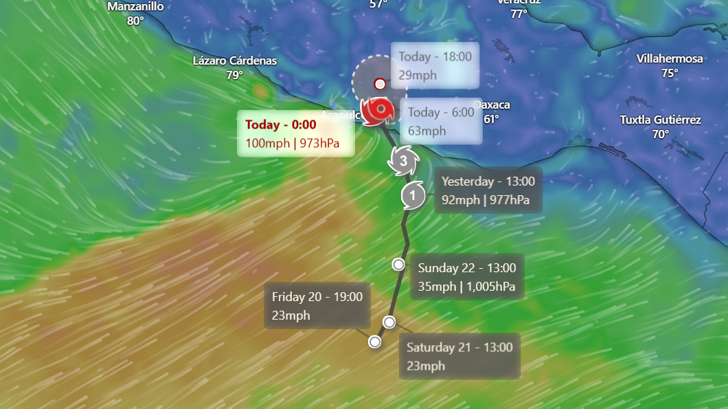
Hurricane John made landfall on Mexico’s southern Pacific coast late Monday with winds of up to 120 mph.
John hit costal regions rapidly intensifying into a Category 3 storm just hours after being classified as a tropical storm.
There are concerns that rapidly intensifying storms are becoming more common as the oceans warm, according to experts.
The intensification of the storm caught officials off guard, who rushed to update evacuation orders.
Mexico’s President Andrés Manuel López Obrador urged coastal residents to seek shelter immediately, warning of dangerous storm surges and flash floods.
“Seek higher ground, protect yourselves, and remember that life is irreplaceable,” López Obrador wrote on social media platform X (formally Twitter).
The U.S. National Hurricane Center had earlier warned of “life-threatening” conditions along the coast, and by the time John made landfall near Punta Maldonado, significant flooding was already underway.
Key tourist destinations, including Puerto Escondido and Acapulco, braced for impact as heavy rains pummeled the region.

NOAA/AP
Experts pointed to the unusually warm ocean waters as a key factor in John’s rapid intensification.
“These are storms we haven’t experienced at this frequency before,” said AccuWeather Senior Meteorologist Matt Benz.
“Rapid intensification has occurred more frequently in modern times as opposed to back in the historical record. So that’s telling us there’s something going on there.”
Federal civil protection authorities called for widespread evacuations across coastal cities.
Laura Velázquez, the country’s civil protection coordinator, said: “It is crucial that everyone in coastal areas takes preventive action and evacuates to safe shelters.”
Local residents, meanwhile, faced mounting anxiety.
Ana Aldai, who works at a restaurant in Puerto Escondido, said that businesses shut down abruptly after the government ordered all activity on the town’s main beaches to halt. “There was little time to prepare.”
In response to the storm, the governors of Oaxaca and Guerrero closed schools across coastal zones and evacuated thousands of people.
Videos circulating online showed tourists wading through rain-soaked streets and fishermen pulling their boats out of the water as the storm approached.
Meteorologist Benz warned that John’s slow movement over land could worsen the situation, potentially prolonging the heavy rains and flooding.
The memory of Hurricane Otis—another rapidly intensifying storm that battered Acapulco last year—was still fresh in the minds of many in the region.
Otis, which also took many by surprise, caused widespread devastation in Acapulco, knocking out power and leaving the city in chaos.
In the aftermath, the government faced heavy criticism for its delayed response.
López Obrador’s administration has since vowed to improve disaster preparedness, and President-elect Claudia Sheinbaum has announced plans to implement an early warning system similar to the country’s earthquake alerts.
Forecasters predict that by Thursday, coastal areas of Chiapas, Oaxaca, and Guerrero could see up to 20 inches of rain, with isolated areas receiving even more. As Benz put it, “The impacts of this storm will likely be felt for weeks, if not months.”
This article includes reporting from The Associated Press