Three major wildfires burning simultaneously in Southern California have burned homes and stretched resources from multiple agencies across four counties this week. Here’s a look at each incident, and the challenges crews face Friday.
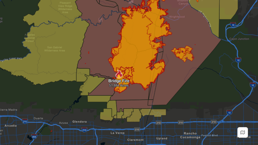
Bridge Fire
The Bridge Fire burning in Los Angeles and San Bernardino Counties started on Sunday and remained the only fire with no containment as of Thursday night. However, progress was made overnight with some containment being reported by fire officials Friday morning. The fire is estimated to have destroyed about 40 structures and is threatening thousands of others.
The latest Cal Fire update was issued at 5:30 p.m. Friday.
- Containment: 3%
- Acres: 52,801
- Date Started: Sept. 8, 2024
- Location: Camp Bonita Road east of Camp Williams
- Cause: Under investigation
Evacuation Map (burn area in orange – mandatory evacuations in red – evacuation warnings in yellow) via Cal Fire:
Evacuation Shelters can be found at Pomona Fairplex: 601 W McKinley Ave, Pomona; San Bernardino County Fairgrounds (Building 6): 14800 7th St, Victorville; Jessie Turner Community Center: 15556 Summit Ave, Fontana and Hacienda Heights Community Center: 1234 Valencia Ave, Hacienda Heights.
Updated information can be found on the Bridge Fire incident page.
Airport Fire
The most recent of the wildfires, the Airport Fire began Monday in Orange County’s Trabuco Canyon before spreading to Riverside County. Containment on the fire increased overnight from 5% to 8%. Officials said the blaze was ignited accidentally by a spark from heavy equipment used by public workers. The Orange County Health Officer issued a Declaration of Local Health Emergency in response to this fire on Friday evening.
The latest Cal Fire update was issued at 5:46 p.m. Friday.
- Containment: 9%
- Acres: 23,494
- Date Started: Sept. 9, 2024
- Location: Trabuco Canyon
- Cause: Spark from heavy equipment
Evacuation Map (burn area in orange – mandatory evacuations in red – evacuation warnings in yellow) via Cal Fire:

Evacuation Shelters can be found at RSM Bell Tower Community Center: 22232 El Paseo, Rancho Santa Margarita; Temescal Canyon High School: 28755 El Toro Road, Lake Elsinore and Santiago High School: 1395 E Foothill Pkwy, Corona.
Updated information can be found on the Airport Fire incident page.
Line Fire
The Line Fire burning in San Bernardino County is the oldest of the three major wildfires starting on Sept. 5. The blaze destroyed at least one home in Running Springs and was believed to have been intentionally caused. Justin Wayne Halstenberg, 34, of Norco has been charged with nine felony counts including arson causing damages of over $7 million, great bodily injury to a firefighter, and possession of incendiary devices.
The latest Cal Fire update was issued at 4:21 p.m. Friday.
- Containment: 25%
- Acres: 38,074
- Date Started: Sept. 5, 2024
- Location: Baseline Street and Aplin Street in Highland
- Cause: Arson
Evacuation Map (burn area in orange – mandatory evacuations in red – evacuation warnings in yellow) via Cal Fire:

Evacuation Shelters can be found at San Bernardino County Fairgrounds (Building 6): 14800 7th St, Victorville; Jessie Turner Community Center: 15556 Summit Ave, Fontana and Hacienda Heights Community Center: 1234 Valencia Ave, Hacienda Heights.
Updated information can be found on the Line Fire incident page.