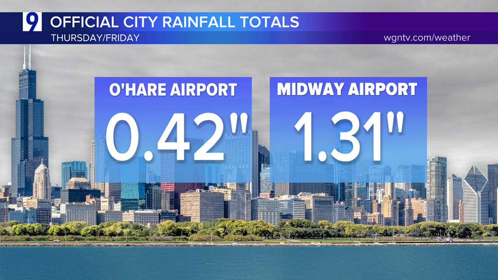
Thursday/early Friday official city totals
Active overnight Thursday thunderstorms into Friday early Friday were punctuated by frequent lightning, gusty winds, and locally heavy downpours in some areas. In typical summertime fashion, thunderstorms hit one area hard but brought very little to other locations.
CITY TOTALS: This includes total rainfall from Thursday and Friday, cumulatively:

Radar generated total rainfall estimate by the NWS Doppler Radar at Romeoville

Heaviest overnight Thursday area totals

Plot of the lightning discharges and where the darker red shaded area depicts the most prolific lightning areas:

Friday evening brought drenching downpours and damaging thunderstorm wind gusts…


COD Goes Satellite and Weather Radar depicts the storms that bubbled up in Friday evening’s warm and humid atmosphere.

Friday evening storms formed in a far warmer, more humid environment with temperatures pushing close to 90 degrees
Friday afternoon temperature snapshot

How much warmer than same period Thursday?

Friday afternoon dewpoints


A cooler-than-normal pattern is locking into the Midwest, Ohio Valley, and Eastern U.S. over the next week.
Forecast temperature anomaly through August 22nd
