Hurricane Debby made landfall Monday morning over Florida’s Big Bend coast, striking land around 7 a.m. ET as a Category 1 storm. Debby was forecast to bring severe and possibly monstrous storm surge — as high as 10 feet above ground level in some areas — to parts of the Gulf Coast of Florida. The storm could bring historic rainfall to surrounding states like Georgia and South Carolina, too, the National Hurricane Center said.
Debby slammed into the Big Bend coast, where the Florida panhandle meets the peninsula, near Steinhatchee, a small oceanside town about 70 miles west of Gainesville. The hurricane center said it was tracking slightly inland in the Big Bend region about an hour after landfall, with maximum sustained winds of 75 miles per hour.

NOAA/National Hurricane Center
Meteorologists expected that storm surge would be most catastrophic in the immediate vicinity of that landfall location, with the latest forecasts indicating a 130-mile stretch of coastline between Yankeetown and the Aucilla River could see surges between 6 and 10 feet above ground. Ten feet is almost as tall as a traditional ranch-style building.
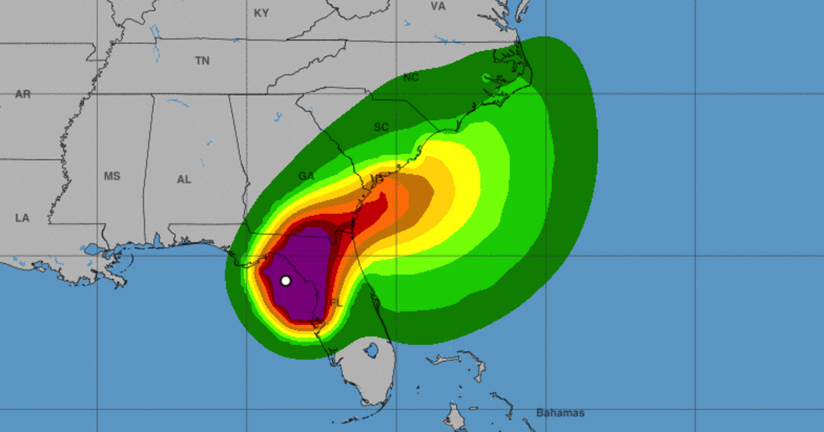
The National Hurricane Center published a map early Monday illustrating the storm surge forecast.
“Water levels along the immediate coast could reach the following heights above ground level within the indicated areas,” reads a description of the map. “Elevated water levels will likely be accompanied by large and destructive waves.”
The figures printed on the map reflect the highest potential values in the peak surge range, and include the tide, the hurricane center said. Meteorologists noted that the timing of peak surge and high tide in a given area, and whether they coincide or not, will ultimately determine how disastrous the inundation will be.

NOAA / National Hurricane Center
Storm surge threats were expected to abate farther into the panhandle and down the length of the Gulf Coast — but only somewhat. Meteorologists warned that surges between 3 and 6 feet could hit areas west of the Aucilla River to Indian Pass, and south of Yankeetown to the Middle of Longboat Key. Debby could usher in as much as 5 feet of storm in and around Tampa Bay.
Coastal places even farther into the Gulf, as far south as Bonita Beach, could see dangerous storm surge as a result of the hurricane. So could coastal areas along a vast stretch of the southeastern United States, from the mouth of the St. Mary’s River, around where Florida meets Georgia, up to the South Santee River in South Carolina. That southeastern stretch includes major cities in both states, Savannah and Charleston, and could weather storm surge up to 4 feet above ground as Debby turns northeastward later on its path.
Debby was expected to slow down after making landfall on Monday, eventually shifting directions on a track anticipated to touch an expansive spread along the southeastern U.S. through the Carolinas before dissipating. In the hurricane center’s most recent path forecast for Debby, released several hours prior to the actual landfall time, meteorologists projected the storm would track from the Big Bend across northern Florida and up through a portion of the eastern coast of Georgia later on Monday and into Tuesday.

NOAA / National Hurricane Center
Forecasts suggested the storm could move off a linear path again late Tuesday and Wednesday, traveling inland while continuing northward to South Carolina and then likely turning back toward the coast on Thursday.
The hurricane center said Debby would probably weaken rapidly after the eye of the storm moved inland into northern Florida, shifting back into a tropical storm at some point Monday afternoon as wind speeds begin to dip. But meteorologists also warned that Debby could strengthen again after an initial period of weakening, depending on whether it oscillates between an inland and coastal path during its route over the southeastern states.
Debby was also expected to dump heavy rain totaling 6 to 12 inches, and even as high as 18 inches in some places, across central and northern Florida as well as central and northeast North Carolina throughout the rest of the week until Saturday morning. Meteorologists warned that the rainfall would likely cause considerable flash and urban flooding, and significant river flooding, in parts of the affected states.
Portions of southeast Georgia, the coastal plains of South Carolina and southeast North Carolina could see 10 to 20 inches of rainfall as Debby continues on its path, with maximum rainfall amounts as high as 30 inches, or almost three feet, in certain areas.

NOAA/National Hurricane Center
A handful of tornadoes could develop over central and northern Florida, as well as southeastern Georgia, on Monday, forecasters said. The tornado threat was expected to travel northeastward with the storm, into parts of South Carolina, later in the day and into Monday night.