Hurricane Helene’s wide and destructive wind field was crossing just west of the Florida Keys on Thursday morning and is expected to rapidly intensify on a direct path for Florida’s Big Bend region, where it could pose “a nightmare surge scenario for Apalachee Bay,” according to the National Weather Service.
The state’s capital, Tallahassee, is directly in Helene’s path. The hurricane’s center is forecast to make landfall late Thursday or early Friday morning.
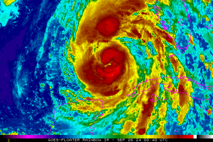
Helene will have one of the largest wind fields of any storm to hit the southeast U.S. in years, according to Colorado State University hurricane researcher Phil Klotzbach, who said that since 1988, only three Gulf hurricanes were bigger than Helene’s predicted size: 2017’s Irma, 2005’s Wilma and 1995’s Opal.
Forecasters said Helene will intensify further than previously forecast, forecasting 130 mph winds Thursday before landfall.
“This forecast, if realized, is a nightmare surge scenario for Apalachee Bay,” the National Weather Service office said. “Please, please, please take any evacuation orders seriously!”
Regardless of where the center comes ashore, Helene will bring widespread and life-threatening conditions to much of the Florida peninsula, including far inland. Tropical storm-force winds were already hitting the Florida Keys overnight and are expected to reach to South Florida by mid-morning Thursday,
The entire coast of Florida is under various warnings. A hurricane warning is in effect on the west coast from north of Tampa Bay to Mexico Beach on the Panhandle. Hurricane and tropical storm warnings encompass nearly the entirety of Florida, including Palm Beach, Broward and Miami-Dade counties.
The fast-moving storm’s wind and rain could also penetrate far inland: The hurricane center posted hurricane warnings well into Georgia and tropical storm warnings as far north as North Carolina, and it warned that much of the Southeast could experience prolonged power outages, toppled trees and dangerous flooding.
For Atlanta, Helene could be the worst strike on a major Southern inland city in 35 years, said University of Georgia meteorology professor Marshall Shepherd.
“Just hope and pray that everybody’s safe,” said Connie Dillard, of Tallahassee, as she shopped at a grocery store with thinning shelves of water and bread before hitting the highway out of town. “That’s all you can do.”
As of 8 a.m. Thursday, Helene was located 320 miles southwest of Tampa, moving north-northeast at 12 mph with sustained winds of 100 mph. Helene will move over the eastern Gulf of Mexico on Wednesday night and Thursday, where conditions are “very conductive for strengthening,” the National Hurricane Center said. It will make landfall in the Big Bend late Thursday.
Parts of South Florida recorded wind gusts as high as 55 mph Wednesday night as Helene’s strong outer bands began to move through the region, according to the National Weather Service Miami.

Sustained winds in South Florida will most likely be below 40 mph. Isolated areas near the Atlantic coast could see higher gusts, according to NWS Miami. West Palm Beach to Miami has a 10 to 15% chance of seeing sustained tropical-storm-force winds, from 39 mph to 73 mph.
Several school districts and universities in the state closed campuses, and government offices and buildings will be closed in many counties. Broward and Palm Beach County schools will close Thursday, along with Broward College, Florida Atlantic University and Palm Beach State College. Schools will be open in Miami-Dade County but with restrictions.
On the west coast, the threat of destructive, life-threatening storm surge is widespread.
“A catastrophic and deadly storm surge is likely along portions of the Florida Big Bend coast, where inundation could reach as high as 20 feet above ground level, along with destructive waves,” the hurricane center said.
Portions of the Panhandle, from Carrabelle to Suwannee River, could receive 15 to 20 feet of storm surge, the hurricane center said.


1 of 20
officials said residents should have their preparations fully complete by now.
In Tallahassee, where stations started to run out of gas, 19-year-old Florida A&M student Kameron Benjamin filled sandbags with his roommate to protect their apartment before evacuating. Their school and Florida State shut down.
“This hurricane is heading straight to Tallahassee, so I really don’t know what to expect,” Benjamin said.
As Big Bend residents battened down their homes, many saw the ghost of 2018’s Hurricane Michael. That storm rapidly intensified and crashed ashore as a Category 5 that laid waste to Panama City and parts of the rural Panhandle. On Wednesday, the National Weather Service posted an urgent warning for residents along Apalachee Bay:
“There is a danger of catastrophic and unsurvivable storm surge for Apalachee Bay,” it said. “Storm surge may begin to arrive as early as late Wednesday night ahead of the winds. This forecast, if realized, is a nightmare surge scenario for Apalachee Bay. Please, please, please take any evacuation orders seriously!”
Tampa International Airport will suspend operations Thursday. There is the possibility of 5-8 feet of surge hitting the Tampa area, if peak surge were to hit at high tide, the National Hurricane Center estimated.
Live webcams: Watch Hurricane Helene’s impacts on Florida coast
Storm surge warnings are in effect from Mexico Beach eastward and southward to Flamingo south of Everglades National Park, including Tampa Bay and Charlotte Harbor.
The large width of the storm is a concern, with tropical-storm force winds extending 345 miles from the center and hurricane-force winds extending up to 35 miles from the center.
“Helene is forecast to be a large major hurricane when it reaches the Big Bend coast of Florida,” forecasters said. “As a result, storm surge, wind, and rainfall impacts will extend well away from the center and outside the forecast cone, particularly on the east side.”
The projected speed of the storm will also likely carry devastating impacts far inland. The National Hurricane Center is forecasting the the storm remain a hurricane well into Georgia, where some universities and school systems have also planned to close Thursday and Friday.
Helene is forecast to be one of the largest storms in breadth in years to hit the region, said Colorado State University hurricane researcher Phil Klotzbach. He said since 1988, only three Gulf hurricanes were bigger than Helene’s predicted size: 2017’s Irma, 2005’s Wilma and 1995’s Opal.
Areas 100 miles north of the Georgia-Florida line can expect hurricane conditions. More than half of Georgia’s public school districts and several universities canceled classes.
“You are going to have a major hurricane plowing inland, and storms take a little time to decay once they’re inland,” said Brian McNoldy, an environmental researcher at the University of Miami.
As residents of Florida’s Big Bend — the curving stretch of Gulf coastline in the state’s north — battened down their homes, many saw the ghost of 2018’s Hurricane Michael. That storm rapidly intensified and crashed ashore as a Category 5 that laid waste to Panama City and parts of the rural Panhandle.
“People are taking heed and hightailing it out of there for higher ground,” said Kristin Korinko, a Tallahassee resident who serves as the commodore of the Shell Point Sailboard Club, on the Gulf Coast about 30 miles south of the state capital.
Palm Beach County schools will close Thursday, while schools will open in Broward and Miami-Dade
In Tallahassee, where stations had started to run out of gas, 19-year-old at Florida A&M student Kameron Benjamin filled sandbags with his roommate to protect their apartment before evacuating. Their school and Florida State shut down ahead of the storm. “This hurricane is heading straight to Tallahassee, so I really don’t know what to expect,” Benjamin said.
Inland areas could receive 5 to 10 inches of rain, with isolated totals around 15 inches, resulting in flash flooding to northwestern and northern Florida, the Southeast, southern Appalachians, and the Upper Tennessee Valley through Friday. Steeper areas of southern Appalachians could see landslides.
“Considerable to locally catastrophic flash and urban flooding is likely for northwestern and northern Florida and the Southeast through Friday,” the hurricane center said.
TRACKING MAP: Where and when will Hurricane Helene hit Florida?
Meanwhile, Tropical Storm Isaac is forecast to become Hurricane Joyce by Friday.
As of 5 a.m. Thursday, Isaac was 755 miles east-northeast of Bermuda with maximum sustained winds of 50 mph, moving east at 12 mph. Tropical-storm-force winds extend up to 70 miles from the storm’s center. It is expected to move east to east-northeast over the open waters of the Atlantic.

Separately, a tropical depression is likely to form in the next few days from a disturbance in the far eastern Atlantic, several hundred miles off the coast of Africa, forecasters said. The system is expected to move west to west-northwest.
As of 5 a.m. Thursday, it has an 80% chance of developing in the next seven days and a 70% chance in the next two days, higher odds than earlier in the day Wednesday.
Experts at Colorado State University issued an updated two-week forecast Sept. 17, calling for a normal of hurricane activity. The forecast says it is very unlikely there will be an above-normal amount of activity through the next two weeks.
After Joyce, the next storm to form would be Kirk.
Hurricane season runs from June 1-Nov. 30, but the height of storm production runs from mid-August into October.
Information from the Associated Press was used in this report.
This is a developing story, so check back for updates. Click here to have breaking news alerts sent directly to your inbox.
Originally Published: