A heat wave was expected to bring record-high temperatures to the midwestern United States this week before spreading to the East Coast, forecasters said. At the same time, a bout of severe thunderstorms was forecast to follow a similar path from the Great Lakes region toward the Mid-Atlantic and southern New England over the next couple of days.
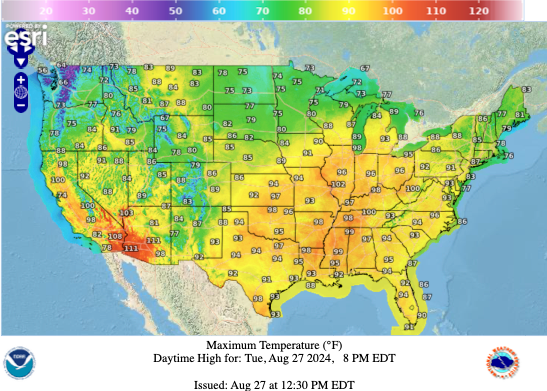
High, and in some instances excessively high, temperatures settled in Tuesday over much of the Midwest, including major metropolitan areas like Chicago and Milwaukee, the National Weather Service said in an advisory that noted portions of the Mid-Atlantic region, including Philadelphia, were also affected. Millions were under various types of heat alerts in response to the weather.
Humidity combined with soaring temperatures to create maximum heat indexes between 105 and 115 degrees across the regions, according to the weather service, which warned of major, and, in a number of places, extreme, heat risks Tuesday across the Midwest and into the lower Great Lakes. The heat index is what the actual temperature feels like when it’s combined with relative humidity.
National Weather Service
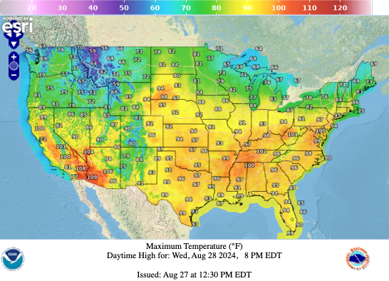
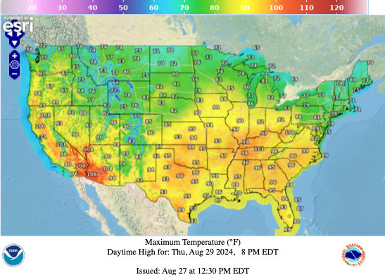
Meteorologists said the heat wave’s expansion eastward, and, eventually, southward, through Thursday “will send a quick spell of potentially record high temperatures” from midwestern states to the Ohio Valley, the Tennessee Valley, parts of the Appalachians and into the Mid-Atlantic region.
“Today, excessively hot temperatures are expected for much of the Midwest including the Chicago and Milwaukee Metros,” the weather service said Tuesday in a social media post. “If you’re working outside today in these areas, ensure you take plenty of breaks in the shade, and drink plenty of water – even if you don’t feel thirsty.”
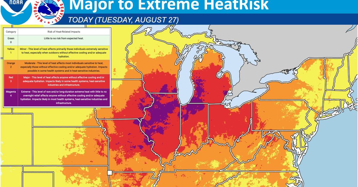
An accompanying map illustrated the spread of the heat wave over a large cluster of midwestern states, with Michigan, Ohio, Indiana, Illinois, Iowa, Wisconsin and Missouri feeling the brunt of it on Tuesday. Huge swaths of land across that region were at risk of heat-related impacts on human health, infrastructure and some sensitive industries.

National Weather Service
Risks in some sections of the area were deemed “moderate” by the National Weather Service, referring to a level of heat that “affects most individuals sensitive to heat, especially those without effective cooling and/or adequate hydration” and at the time of the latest weather update extended far into the Mid-Atlantic as well as the Northeast. But the situation posed blanket threats to people living almost anywhere in states like Illinois, Ohio and Michigan, where forecasters deemed the risks in most places to be either “major” or “extreme.”
The former designation warns of heat levels that would affect “anyone without effective cooling and/or adequate hydration” and would likely also impact “some health systems, heat-sensitive industries and infrastructure.” The latter describes a “level of rare and/or long-duration extreme heat with little to no overnight relief,” which would similarly affect anyone under certain circumstances.
National Weather Service
CBS News senior weather producer David Parkinson reported early Tuesday that heat in the Chicago metro area would likely feel like 108 degrees, with temperatures in Louisville approaching triple digits, albeit with slightly less humidity. Nashville will experience the worst of the heat wave on Wednesday, with temperatures expected to exceed 100 degrees, while Washington, D.C., could see a record high of 99 degrees — potentially clocking its 47th day above 90 degrees this year. That would be well above the capital’s average in 2023 but below the all-time record of 67 days with above-90 temperatures, Parkinson said.
Severe storms will sweep through N.Y., Philly and D.C. on Wednesday, ushering in much cooler temperatures. It’s important to note none of the major northeast cities will have a heat wave, as there won’t be three consecutive 90 degree days. That goes for DC as well. As the week ends, only the Tennessee River Valley holds on to record heat, as areas to the north return to and stay close to normal.
National Weather Service
Excessive heat warnings and heat advisories were active for 61 million people across the Mississippi Valley, the Midwest and southern New England on Tuesday, the weather service said. Forecasters added that those warnings and advisories were expected to spread into parts of the Mid-Atlantic by Wednesday as the heat wave moves in that direction.
A heat advisory was in effect through Tuesday night for southeastern Michigan, where forecasters expected actual temperatures to exceed 90 degrees and push the heat index in some areas up to 100.
A heat advisory was also in effect for a large part of northwestern Indiana on Tuesday, with an excessive heat warning in place for most of northern Illinois, according the weather service in Chicago.
“The hottest day of the heat wave is expected today with heat indices climbing to 105 to 110 degrees,” the Chicago forecasters said in a social media post. They noted that some of those same areas could be hit with thunderstorms starting late Tuesday afternoon into Tuesday night.
“An Air Quality Alerts continue through midnight tonight for northeast Illinois and northwest Indiana,” that post continued. “Air quality is expected to be at unhealthy levels for sensitive groups. Limit prolonged outdoor activity, especially those with chronic respiratory illnesses.”