
A hurricane watch has been issued for a portion of Florida’s Gulf Coast as Tropical Depression Four moves toward the Gulf of Mexico, according to the latest advisory from the National Hurricane Center.
The depression is expected to become Tropical Storm Debby later today and to approach hurricane strength before making landfall.
➤ Live updates: Get the latest on Tropical Depression 4 as it approaches Florida
➤ Spaghetti models for Tropical Depression Four
Florida Gov. Ron DeSantis Thursday declared a state of emergency Thursday for 54 counties. Seven more counties were added late Friday, putting 61 of Florida’s 67 counties under a state of emergency.
To become a tropical storm, sustained winds must reach 39 mph.
Sustained winds were at 30 mph as of the 5 a.m. advisory.
Where is Tropical Depression Four?
-
Location: 80 miles south-southeast of Varadero, Cuba; 195 miles south-southeast of Key West
-
Maximum sustained winds: 30 mph
-
Movement: west-northwest at 16 mph
-
Next advisory: 8 a.m. Aug. 3
Tropical Depression Four expected to strengthen into Tropical Storm Debby
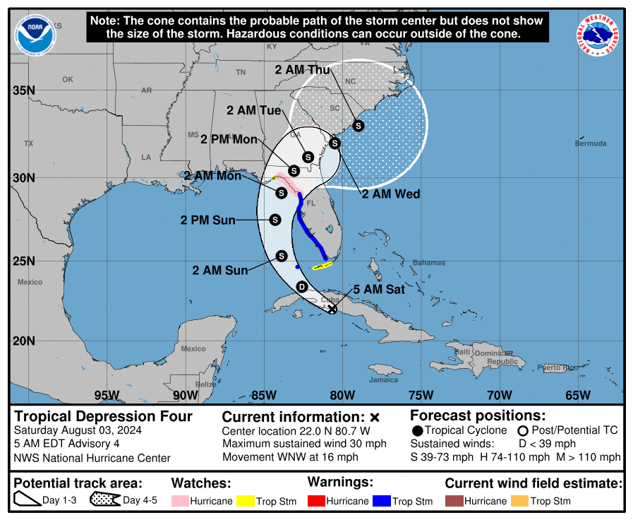
At 5 a.m., the center of Tropical Depression Four was located near latitude 22.0 North, longitude 80.7 West.
The depression is moving toward the west-northwest near 16 mph. A turn toward the northwest is forecast today, followed by a northward motion on Sunday and then a slower northeastward motion Sunday night and Monday.
➤ How could tropical storm affect your weekend plans?
On the forecast track, the center of the depression will move across western Cuba this morning, and then move over the eastern Gulf of Mexico later today and Sunday, reaching the Florida Gulf Coast late Sunday or Monday.
Maximum sustained winds are near 30 mph, with higher gusts.
Strengthening is forecast during the next couple of days, and the depression is expected to become a tropical storm later today and continue strengthening over the eastern Gulf of Mexico through the weekend.
The estimated minimum central pressure is 1009 mb.
Spaghetti models: Latest forecasts on where Tropical Depression Four could make Florida landfall
Special note about spaghetti models: Spaghetti model illustrations include an array of forecast tools and models, and not all are created equal. The Hurricane Center uses only the top four or five highest performing models to help make its forecasts.
Hurricane, tropical storm watches and warnings issued for Florida
A hurricane watch is in effect for:
A hurricane watch means that hurricane conditions are possible within the watch area. A watch is typically issued 48 hours before the anticipated first occurrence of tropical-storm-force winds, conditions that make outside preparations difficult or dangerous.
A tropical storm warning is in effect for:
A tropical storm warning means that tropical storm conditions are expected somewhere within the warning area within 36 hours.
A tropical storm watch is in effect for:
A tropical storm watch means that tropical storm conditions are possible within the watch area, generally within 48 hours.
A storm surge watch is in effect for:
A storm surge watch means there is a possibility of life-threatening inundation, from rising water moving inland from the coastline, in the indicated locations during the next 48 hours.
Potential impacts from Potential Tropical Cyclone Four
WINDS: Hurricane conditions are possible in the hurricane watch area by Sunday night, with tropical storm conditions possible by Sunday. Tropical storm conditions are expected to spread northward over the warning areas beginning later today and continuing through Sunday. Tropical storm conditions are possible in the watch area in the Florida Keys later today or tonight, and in the Florida Panhandle by late Sunday.
STORM SURGE: The combination of storm surge and tide will cause normally dry areas near the coast to be flooded by rising waters moving inland from the shoreline. The water could reach the following heights above ground somewhere in the indicated areas if the peak surge occurs at the time of high tide:
-
Chassahowitzka, FL to Aucilla River, FL…3-5 feet
-
Bonita Beach, FL to Chassahowitzka, FL…2-4 feet
-
Tampa Bay…2-4 feet
-
Charlotte Harbor…2-4 feet
RAINFALL: Tropical Depression Four is expected to produce rainfall totals of 5 to 10 inches, with maximum rainfall totals up to 15 inches, across portions of Florida and along the Southeast U.S. coast this weekend through Thursday morning. This rainfall may result in areas of locally considerable flash and urban flooding, with isolated river flooding possible.
TORNADOES: A tornado or two is possible across the Florida Keys and the western Florida Peninsula tonight through Sunday morning.
SURF: Swells generated by the depression are expected to affect much of the Gulf coast of Florida tonight through Monday and along the Southeast U.S. coast early next week. These swells are likely to cause life-threatening surf and rip current conditions.
Key messages on what Florida can expect from tropical cyclone
-
Heavy rainfall may result in locally considerable flash and urban flooding across portions of Florida and the coastal areas of the Southeast U.S. this weekend through Wednesday. Isolated river flooding will also be possible.
-
A hurricane watch has been issued for portions of west-central Florida and the Big Bend region, where hurricane conditions are possible late Sunday. Tropical storm conditions are expected farther south along Florida’s west coast, including the Tampa Bay area, and across the Dry Tortugas where Tropical Storm Warnings are in effect.
-
There is a possibility of life-threatening inundation from storm surge along portions of the west coast of Florida from Bonita Beach to Aucilla River, including Tampa Bay and Charlotte Harbor, where a Storm Surge Watch is in effect.
-
Impacts from storm surge, strong winds, and heavy rains are possible elsewhere in Florida and along the southeast coast of the United States from Georgia to North Carolina through the middle of next week, and interests in those areas should continue to monitor the progress of this system. Additional watches and warnings will likely be required later today.
Florida Gov. DeSantis issues state of emergency for 61 counties
Florida is monitoring Invest 97L in the Atlantic, which is expected to strengthen and potentially make landfall as early as this weekend. It will be slow-moving and bring lots of rain that could cause significant flooding.
I encourage all residents to prepare for the storm and…
— Ron DeSantis (@GovRonDeSantis) August 1, 2024
Gov. Ron DeSantis issued a state of emergency Thursday for 54 counties in preparation for the potential landfall of a storm that could become the first “significant threat” to the state.
Friday night, he added another seven counties. That brings 61 of the state’s 67 counties under a state of emergency.
Weather watches and warnings issued in Florida
When is the Atlantic hurricane season?
The Atlantic hurricane season runs from June 1 through Nov. 30.
When is the peak of hurricane season?
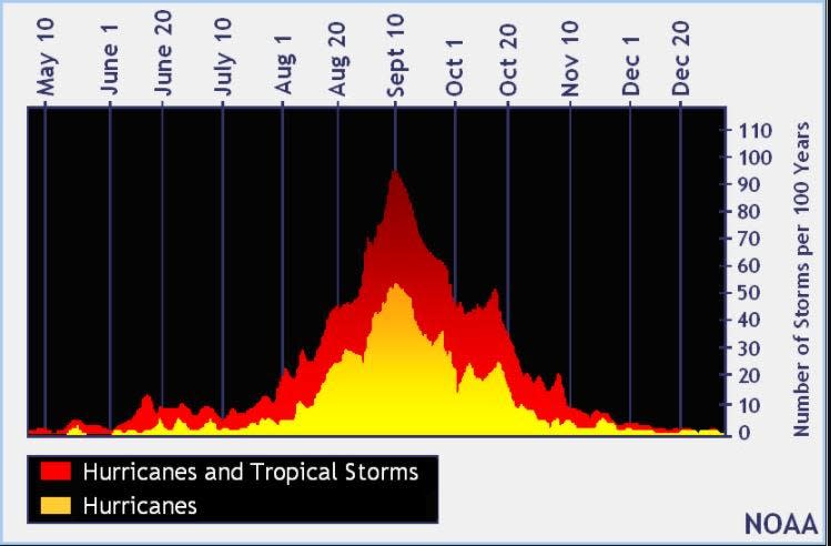
The peak of the season is Sept. 10, with the most activity happening between mid-August and mid-October, according to the Hurricane Center.
National Hurricane Center map: What are forecasters watching now?
Systems currently being monitored by the National Hurricane Center include:

Interactive map: Hurricanes, tropical storms that have passed near your city
Excessive rainfall forecast
What’s next?
We will continue to update our tropical weather coverage daily. Download your local site’s app to ensure you’re always connected to the news. And look for our special subscription offers here.
This article originally appeared on Fort Myers News-Press: Tropics update: Tropical Storm Debby, watches,warning