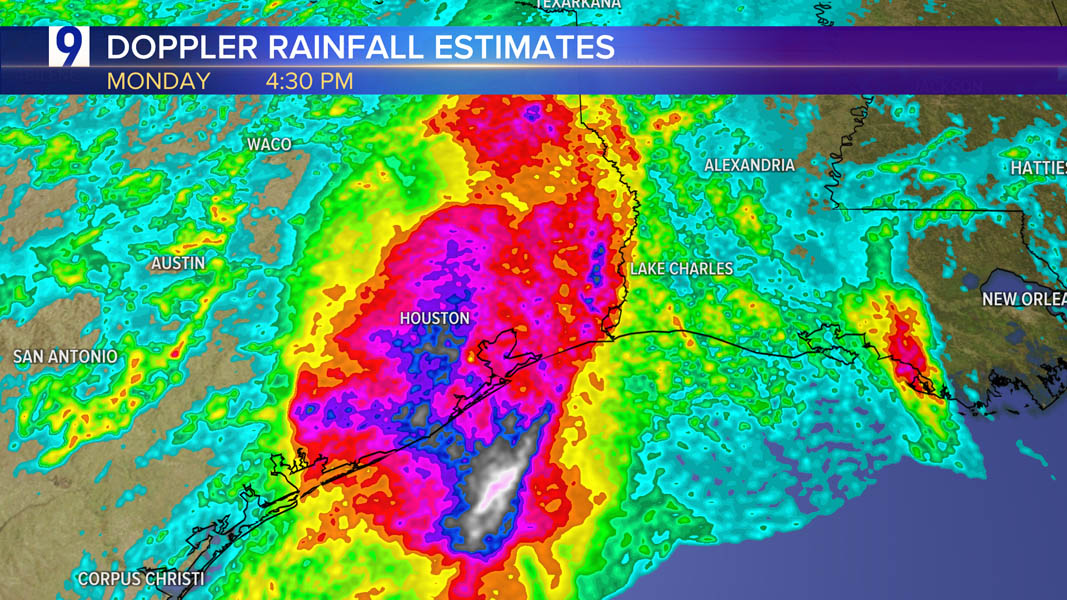
Beryl unleashes flooding rainfall and hurricane force wind gusts to southeast Texas
Heaviest rainfall totals

Peak wind gusts

Hurricane Beryl Meteorological Records/Notable Facts Recap (Valid 15 UTC on 8 July)

From Dr. Philip Klotzbach, Colorado State University:
While the Atlantic hurricane database (HURDAT2) goes back to 1851, there are likely underestimates in storm intensities before the satellite era which began in 1966. Pressure data is only consistently reported in the Atlantic hurricane database (HURDAT2) since 1979.
Intensity Measures.
- 165 mph (Category 5) lifetime maximum sustained winds – strongest maximum
sustained winds for an Atlantic hurricane prior to August on record. Old record
(Emily, 2005 – 160 mph – also a Category 5).
- 934 hPa lifetime minimum central pressure – 3rd lowest central pressure for an
Atlantic hurricane prior to August on record. Trailing (Emily, 2005 – 929 hPa and
Dennis, 2005 – 930 hPa).
- Earliest Atlantic Category 4 hurricane on record (30 June at 18 UTC). Old record
was Dennis (8 July 2005 at 0 UTC).
- Earliest Atlantic Category 5 hurricane on record (2 July at 3 UTC). Old record was
Emily (17 July 2005 at 0 UTC).
- Beryl became a hurricane at 49.3°W – the farthest east an Atlantic hurricane had
formed in the tropics (south of 23.5°N) in June on record. Old record was Cuba-
Brownsville of 1933 (59°W).
- 65 mph/24 hr intensification rate from 29 June – 30 June – the fastest 24 hr
intensification rate for an Atlantic named storm this early in the calendar year on
record. Previous earliest 65 mph/24 hr intensification rate was Bertha (2008) from
6 July – 7 July.
- ~35 Accumulated Cyclone Energy (ACE) – the most ACE by a single Atlantic storm
getting named prior to 1 August on record. Old record was Emily (2005 – ~33
ACE).
- 4.5 major (Category 3+) hurricane days – the most for a storm getting named
prior to 1 August on record. Old record was Emily (2005 – 4.25 major hurricane
days).
- 9.75 named storm days – 6th most for a storm getting named prior to 1 August
on record.
- 6.25 hurricane days – 7th most for a storm getting named prior to 1 August on
record.
Landfalls: - Carriacou Island, Grenada: 150 mph, 950 hPa – Category 4 (1 July, 1510 UTC)
- Strongest hurricane on record to make landfall in Grenada. Hurricane Ivan
(2004) did not officially make landfall on Grenada but passed ~10 miles south of
the main island of Grenada with maximum winds estimated at 125 mph,
damaging 90% of the homes on the island. - Quintana Roo, Mexico: 110 mph, 975 hPa – Category 2 (5 July, 1105 UTC)
- First Category 2+ hurricane to make landfall in Quintana Roo in July since
Emily (2005) (Category 4, 130 mph) - Matagorda, Texas: 80 mph, 979 hPa – Category 1 (8 July, 9 UTC)
- Earliest calendar year hurricane landfall in Texas since Bonnie (26 June
1986) - 10th hurricane to make landfall in Texas in July on record and the first since Hanna in 2020.
Source: Dr. Philip Klotzbach, Colorado State University