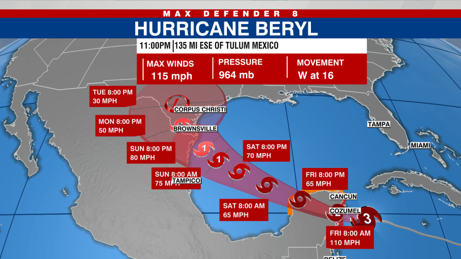
TAMPA, Fla. (WFLA) — Hurricane Beryl strengthened into a Category 3 storm again Thursday night as it approaches the Yucatan Peninsula, according to the National Hurricane Center.
As of the NHC’s 11 p.m. update, the storm was 135 miles east-southeast of Tulum, Mexico, with winds of 115 mph. Beryl is expected to have “little change in strength” before it makes landfall.
As the storm crosses the peninsula, it’s expected to weaken significantly, but will slowly re-intensify once it gets back into the Gulf of Mexico, the NHC said.
Friday night, Beryl is expected to emerge over the southwestern Gulf of Mexico and turn northwestward toward northeast Mexico and southern Texas.
The NHC said rip currents could cause life-threatening beach conditions beginning late Friday and continuing through the weekend across much of the Gulf Coast.
The following watches and warnings are currently in effect:
A Hurricane Warning is in effect for…
- The coast of the Yucatan Peninsula of Mexico from Puerto Costa
Maya to Cancun, including Cozumel
A Hurricane Watch is in effect for…
- The coast of the Yucatan Peninsula of Mexico south of Puerto
Costa Maya to Chetumal - The coast of the Yucatan Peninsula of Mexico north of Cancun to
Cabo Catoche
A Tropical Storm Warning is in effect for…
- The coast of the Yucatan Peninsula of Mexico south of Puerto
Costa Maya to Chetumal - The coast of the Yucatan Peninsula of Mexico north of Cancun to
Campeche
A Tropical Storm Watch is in effect for…
- Coast of Belize from south of Chetumal to Belize City