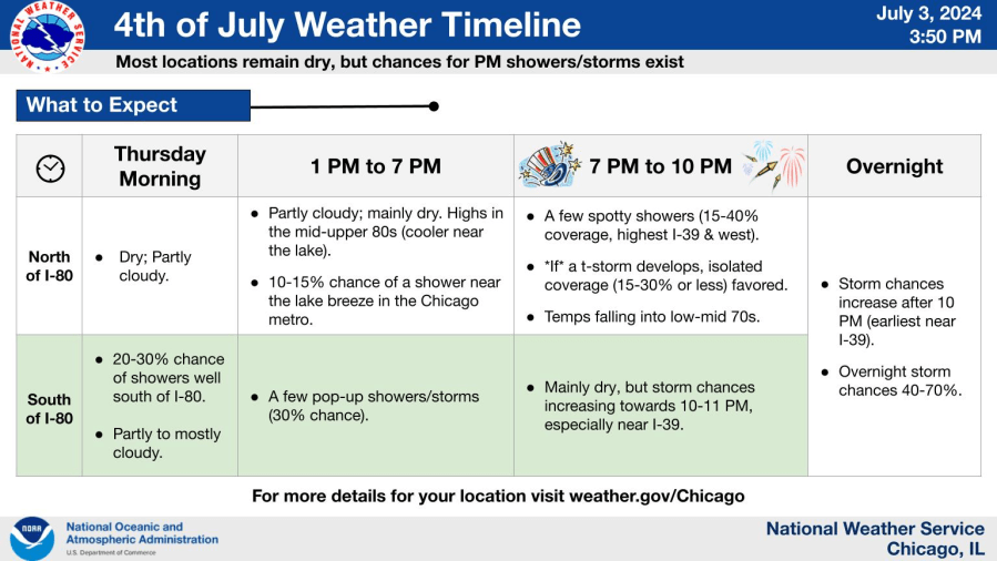
Most areas will be rain-free but small chances exist for a pop-up shower or thunderstorm Thursday afternoon and, a better chance later Thursday night.
Rain chances through the holiday weekend
The greatest chance for areawide shower and thunderstorm activity will occur late Thursday night/early Friday morning. And while rain chances aren’t zero during other periods, there will be far more dry hours than wet ones.


July 4th climatology—more than 40% of the years have logged highs in the 80s and this year will be no exception with the predicted high temperature in the middle 80s.


How does the holiday stack up in terms of warmest and coolest highs?
How are things shaping up across the country?

Extremely dangerous and potentially deadly heat will expand in the Western U.S. where some all-time record high temperatures will be possible in coming days.

20 states across the country under some sort of heat advisory/warning or watch

Heat to build across the lower 48—but temperatures are to remain under control across the Chicago area
…FORECAST HIGHS ACROSS THE COUNTRY…
July 4 highs: 128 million U.S. residents above 90 degrees

Friday, July 5th highs: 130 million U.S. residents to log highs above 90 degrees.

Saturday, July 6th highs: 137 million U.S. residents to log highs above 90 degrees:

Potential total rainfall next 7 days through Wednesday, July 10
Portions of the Upper Midwest and North Woods are again likely to see heavy amounts of rainfall with general totals across the Chicago area between 0.50” and 1.00”
