
The hurricane center is tracking potential cyclone one, a tropical system that could strengthen into the first named storm of the season as soon as Tuesday.
National Hurricane Center
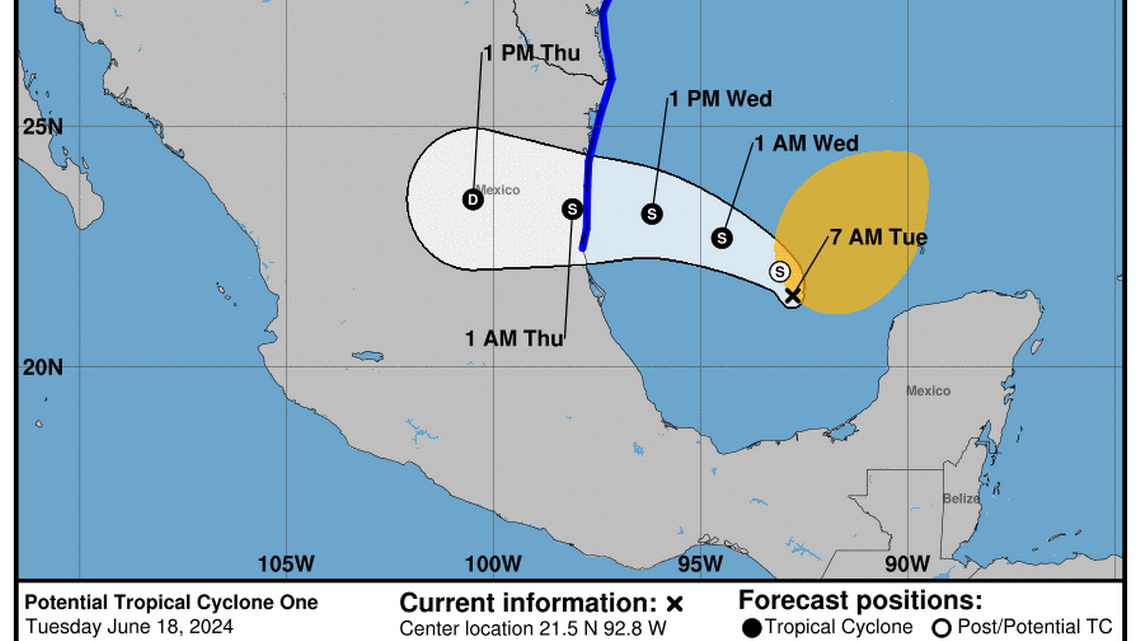
The season’s first named storm could form in the Gulf of Mexico very soon, deluging coastal Mexico and Texas with double-digit rainfall. And near Florida, a disturbance set to bring more rain to the state appears to be weakening.
The National Hurricane Center is tracking the tropical system, which is projected to beeline straight into Mexico — potentially as Tropical Storm Alberto — late Wednesday night. This has prompted tropical storm warnings in Mexico and tropical storm watches in Texas.
But there’s a chance the struggling system could fail to organize, the hurricane center warned. Either way, it’s expected to bring an intense amount of rain to the region, with inches falling as far as Louisiana. The hardest hit spots could see up to 15 inches of rain.

As of 8 a.m. Tuesday, the system maintained its tropical-storm-strength 40 mph sustained winds but failed to organize overnight.
“Since the system still lacks a well-defined center it will continue to be designated as a potential tropical cyclone,” the hurricane center said.
Disturbances
The hurricane center is also watching two disturbances, one near Florida. The system — a disorganized collection of thunderstorms — appeared to be weaker on Tuesday morning than it was the day before.
Forecasters lowered its chances of strengthening from 30% in the next week to 20% but said the system still had a chance of gradually developing in the next few days as it nudges away from the Bahamas and nears the U.S. East Coast.
The system could provide an extra boost of moisture in the air when it is closest to Florida, potentially adding a little more rain to the usual afternoon showers later in the week.
Monday night, the hurricane center also started watching a second disturbance in the same area as the potential tropical cyclone near Texas. This one also has a low chance of strengthening in the next week — 20%.