Tropical Storm Ian is predicted to strengthen into a hurricane once again as it moves over the Atlantic Ocean, before making a new landfall in South Carolina on Friday.
National Hurricane Center
hide caption
toggle caption
National Hurricane Center

Tropical Storm Ian is predicted to strengthen into a hurricane once again as it moves over the Atlantic Ocean, before making a new landfall in South Carolina on Friday.
National Hurricane Center
Ian is exiting Florida as a tropical storm — but as it moves back over the water, it will likely regain hurricane status, drawing power from the Atlantic Ocean. Forecasters are warning of a dangerous storm surge and other impacts, from Florida to North Carolina.
“Ian is expected to become a hurricane again this evening and make landfall as a hurricane on Friday,” the National Hurricane Center said.
A hurricane warning — meaning hurricane conditions are expected within the area in the near future — is now in effect for the entire coastline of South Carolina.
“If you haven’t yet made plans for every contingency, this afternoon is the time to do so,” Gov. Henry McMaster said on Thursday.

The new round of warnings for the Atlantic Coast comes as residents and emergency crews on the western side of the Florida peninsula take stock of the immense damage done by Ian’s massive storm surge and high winds.
“Widespread, life-threatening catastrophic flash and urban flooding, with major to record flooding along rivers, will continue across central Florida,” the hurricane center said.
Ian’s winds are nearly at hurricane strength

People walk to look at the ocean in Tybee Island, Ga., near Savannah, as the effects of Hurricane Ian reached the area early Thursday. The storm is expected to regain some strength over the Atlantic.
Alex Brandon/AP
hide caption
toggle caption
Alex Brandon/AP

People walk to look at the ocean in Tybee Island, Ga., near Savannah, as the effects of Hurricane Ian reached the area early Thursday. The storm is expected to regain some strength over the Atlantic.
Alex Brandon/AP
As of 11 a.m. ET, Tropical Storm Ian’s center was about 25 miles north-northeast of Cape Canaveral, Fla. It currently has maximum sustained winds of 70 mph, with a recent gust measured at 74 mph — the threshold for hurricane strength.
Ian is now projecting tropical storm-force winds up to 415 miles from its center. Current forecasts predict it will hit South Carolina as a Category 1 storm.
But as in western Florida, water poses the main threat: Ian will bring a storm surge, and it’s heading northeast at only 9 mph, a slow pace that heightens the risk of flood-inducing rainfall.
The storm is very large, putting a wide area at risk. A long stretch of the coast is under warning of a life-threatening storm surge, from Palm Coast, Fla., up through the entire shorelines of Georgia and South Carolina.
Forecast track predicts Ian will move inland over S.C.

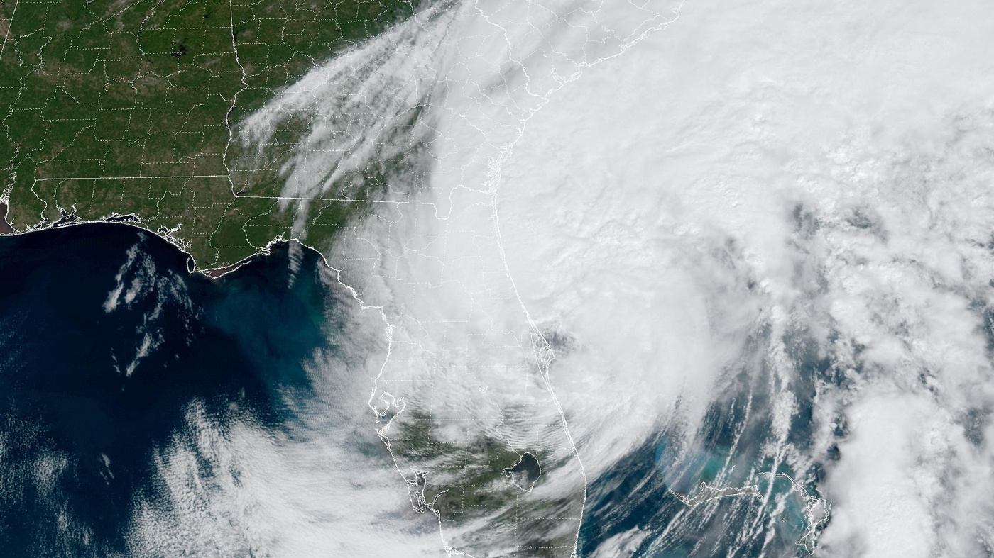
Tropical Storm Ian will regain some of the power it lost passing over land as it, returning to hurricane status later Thursday, according to the National Hurricane Center. It’s seen here shortly before noon ET.
NOAA/NESDIS/STAR
hide caption
toggle caption
NOAA/NESDIS/STAR

Tropical Storm Ian will regain some of the power it lost passing over land as it, returning to hurricane status later Thursday, according to the National Hurricane Center. It’s seen here shortly before noon ET.
NOAA/NESDIS/STAR
The current forecast track sees Ian moving out northeast over the ocean as it passes Jacksonville, before turning more to the northwest and making landfall between Savannah, Ga., and Charleston.
Tropical-storm-force winds will start affecting Georgia and South Carolina Thursday, the NHC said. The combination of storm surges and torrential rain could bring “considerable urban and flash flooding, especially Friday,” according to the National Weather Service office in Charleston. Some areas could see a storm surge 4-7 feet above ground, it said.
“While we will not see the full force of Hurricane Ian the way Florida did, we could see high winds, rain, flash flooding and even tornadoes,” S.C. Emergency Management Director Kim Stenson said.
The “1st round of coastal flooding” is expected to hit South Carolina with Thursday afternoon’s high tide, the NWS office in Charleston reported. Additional flooding will likely continue through Friday, it warned.
Many areas along the coast could also see up to 8 inches of rain, the office said.