AUSTIN (KXAN) – Not since October 2021 have we had 5 consecutive days of measurable rainfall in Central Texas, but we expect to have that next week.
Tropical moisture coming from the south, plus a trough of low pressure planting itself over Texas will provide the perfect recipe for daily showers, thunderstorms and downpours.
Sunday
A few spotty showers possible in the morning with a few afternoon thunderstorms, generally near and east of I-35. A late evening cluster of storms may approach the Hill Country. Rain chances Sunday are at 40%.
Monday-Wednesday
This should be when we receive the majority of our rainfall for the week as a series of disturbances push through, aided by daytime heating and a “cold” front that will be gradually sliding through the area.
Storms and showers will be possible at any time, but coverage will generally become most widespread during the afternoons and early evenings.
Daily storm timing will be a little tough to narrow down at first as these disturbances push through.
Rainfall amounts
There is still some disagreement among our computer models regarding rainfall amounts.
The European computer model (ECMWF) (both deterministic and ensembles) has been trending lower with rainfall amounts.
The American model (GFS) has consistently pointed toward several inches of rain across the entire area.

The National Weather Service’s Weather Prediction Center, to their credit, have remained relatively consistent in their expectation for several inches across Central Texas.

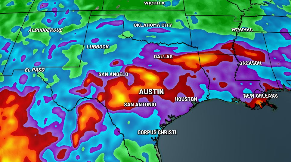
Our take? A widespread 2-4″ of rain seems like a good bet by next weekend, but the tropical nature of these downpours could make for some much higher totals in localized areas.
Flash flooding
Despite our ongoing drought, flash flooding will be a concern almost each day next week as tropical moisture will enhance rainfall rates across the area.
On top of that, our drier soil may actually cause more runoff than wetter soil would, especially earlier in the week.
The Weather Prediction Center has most of us at a “slight” (Level 2 out of 4) risk for Flash Flooding Monday, Tuesday and Wednesday.


Remember, if you come across a flooded street “turn around, don’t drown.”
Severe weather
While our severe weather risk is relatively low, wet microbursts will be possible with some of the stronger thunderstorms. Damaging winds would be our greatest severe weather risk with a very low hail and tornado threat most of the week. Flash flooding poses our greatest risk overall.
Thursday, Friday, NEXT weekend and beyond…
As the aforementioned “cold” front gradually pulls away, our rain and storm chances will gradually fade with it. Still, the long-term extended forecasts continue to point to wetter than normal weather to wrap-up August and to begin September.

FIRST WARNING WEATHER: Stay up to date with your Central Texas forecast, sign up for our weather newsletter at kxan.com/newsletters