
Strong warning by the National Hurricane Center
Extremely dangerous and life-threatening situation. Persons should not leave their shelters and remain in place through the passage of these life-threatening conditions.
First Category 4 or stronger storm on record to make landfall in Florida’s Big Bend area


Hazards as Helene came ashore
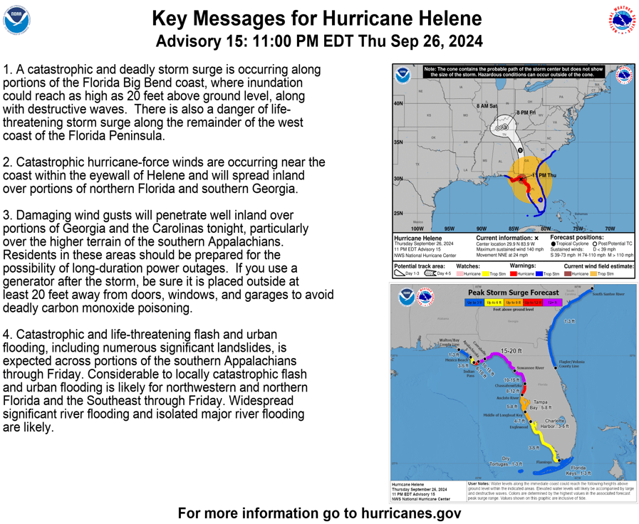
STORM SURGE:
The combination of a life-threatening storm surge and the tide cause normally dry areas near the coast to be flooded by rising waters moving inland from the shoreline. The water could reach the following heights above ground somewhere in the indicated areas if the peak surge occurs at the time of high tide…
- Carrabelle, FL to Suwannee River, FL…15-20 ft
- Apalachicola, FL to Carrabelle, FL…10-15 ft
- Suwannee River, FL to Chassahowitzka, FL…10-15 ft
- Chassahowitzka, FL to Anclote River, FL…8-12 ft
- Indian Pass, FL to Apalachicola, FL…6-10 ft
- Anclote River, FL to Middle of Longboat Key, FL…5-8 ft
- Tampa Bay…5-8 ft
- Middle of Longboat Key, FL to Englewood, FL…4-7 ft
- East of Mexico Beach, FL to Indian Pass, FL…3-5 ft
- Englewood, FL to Flamingo, FL…3-5 ft
- Charlotte Harbor…3-5 ft

The deepest water will occur along the immediate coast near and to the east of the landfall location, where the surge will be accompanied by large and dangerous waves.
Surge-related flooding depends on the relative timing of the surge and the tidal cycle, and can vary greatly over short distances.
WIND:
Hurricane conditions were occurring within the hurricane warning area. Strong, damaging winds, especially in gusts, will likely penetrate as far inland as the higher terrain of the southern Appalachians.

RAINFALL:
Over portions of the Southeastern U.S. into the Southern Appalachians, Helene is expected to produce total rain accumulations of 6 to 12 inches, with isolated totals around 20 inches. This rainfall will likely result in catastrophic and potentially life-threatening flash and urban flooding, along with significant river flooding. Numerous significant landslides are expected in steep terrain across the southern Appalachians.


TORNADOES:
The risk for several tornadoes continues through Thursday tonight over much of Florida, southeast Georgia, central and southern South Carolina, and southern North Carolina. The tornado risk will continue Friday across the Carolinas and southern Virginia.

Monitoring the Atlantic

The National Hurricane Center is issuing advisories on Hurricane
Helene, located inland over southern Georgia and on Tropical Storm
Isaac, located over the central Subtropical Atlantic Ocean.
Western Caribbean:
An area of low pressure could form over the western Caribbean Sea by
the middle of next week. Environmental conditions are expected to be
conducive for slow development thereafter, while the system moves
generally northwestward, potentially entering the Gulf of Mexico by
the end of next week.
* Formation chance through 48 hours...low...near 0 percent.
* Formation chance through 7 days...low...30 percent.
The post Catastrophic winds as the storm moved onshore in the Florida Big Bend region late Thursday appeared first on Patabook News .